Tag Archives: Salish Sea

Glaciers brought mountain to man (not really)

Dionisio Point. Main vlillage sites in central upper portion of image. Credit: Colin grier via NPR.

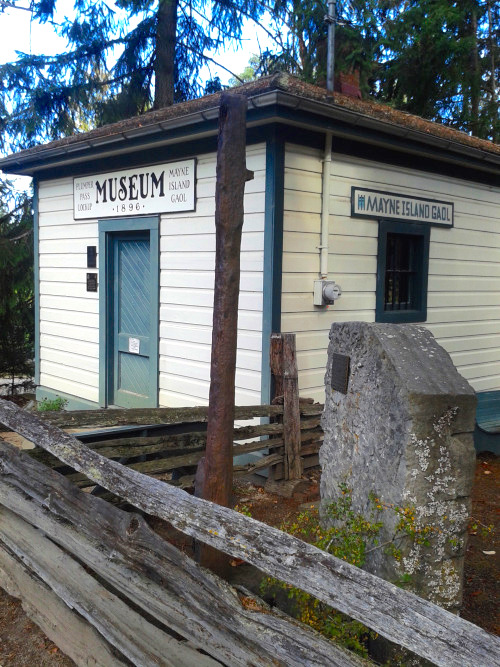
Dionisio Point, north end of Galiano Island. Main vlillage sites (DgRv 6) in central upper portion of image. Credit: Colin grier via NPR.

A couple of months ago you may have heard of an exciting new study on the sources of rock for making stone tools in the Salish Sea.  “Glaciers brought mountain to man“, the headlines said, affirming that archaeologists working on Galiano Island had found nodules of raw material, not yet worked into tools, from the Mt. Garibaldi area of the lower mainland.  If, like me, you have a rudimentary knowledge of Salish Sea archaeology, you probably leapt to the conclusion that the raw material would be from the Garibaldi obsidian source.  So, cool: the mountain moves to Mohammed after all.  But, despite my being fairly disapproving of both sobriety and thinking in general, sober second thought did have me wondering: is it even possible that glaciers carried raw material from Garibaldi to Gabriola?  And from the relatively small and isolated high-altitude obsidian sources to a prominent village site?  ” It was brought there by glaciers, conveniently, 12,000 years ago”, the article asserts – thousands of years past the local ice maximum.  It didn’t easily compute. Luckily I was emailing with one of the paper’s authors, Dr. Colin Grier from Washington State University, and he set me straight on how the new article came to have something of a misleading takeaway point, while shedding some light on his recent interactions with the press.

Continue reading

More Mayne Island Museum

Unusual object in the Mayne Island Museum

Unusual object in the Mayne Island Museum, and two celts.

The above is maybe the most unusual object I saw in the archaeological cases in my visit to the Mayne Island museum.  As you can see, it’s labelled as a “large stone abrader” and may well be, I suppose.  It’s thin, an the reddish cast and sort of laminate structure of the rock makes me think it is schist, a material commonly used for flaked “slate” as well as for saws.  If it’s an abrader, I’d say it’d be a saw, since no sign (on this face) of any smooth abraded areas.  However, the general shape seems pretty elaborate for any abrader or saw from my experience. Maybe an elaborate ulu-style knife intended to be hafted across the neck.  Or, what I was wondering when I was there, maybe triggered by a false association to the shape, was something like the ground slate mirrors from the North Coast.  These would be polished to a sheen, then wetted, thus providing a reflection, and if memory serves (and it often doesn’t) were used in rituals more than for popping blackheads. But it doesn’t seem polished enough for that.  All the same, the shape rings a bell and rather than spend too much time looking through old Syesis’s (Syeses?  Syesisis?? ‘copies of the journal Syesis’ – phew) I’m throwing it out here for comment.

There’s a few other pictures form the museum below.

Continue reading

Visiting Celts at the Mayne Island Museum

Mayne Island Museum and Gaol. Source: tumblr

Mayne Island Museum and Gaol. Source: http://gulfislandsnprcoop.tumblr.com/

The only thing better than small town museums are small town thrift shops, but it’s close. I stuck my nose into the Mayne Island — a small island in the Salish Sea — Museum a day or two ago, which is housed in the former gaol  (that’s “jail” for my diverse readers).  These museums can be fun, but you do have to put on your “this place is historically situated” eyeglasses.  As in, there is usually an enormous preponderance of Settler material, and often there is a fairly reductionist, colonialist or otherwisely unfortunate depiction of First Nations. The Mayne museum doesn’t escape this altogether.  The First Nations display is probably 5% of the total, both in material display, and in the timeline presented (I didn’t take a picture but it is typed out pretty much verbatim here, compare to my pie chart timeline).  Anyway, I don’t want to focus on any negative vibes from the museum, they share the general issues of almost every community museum I’ve been to, but neither do I want to ignore them completely. To their credit they have a good section  the Japanese Internment Camps and the fate of Japanese-Canadian islanders during World War II.  Anyway, I took a few lousy pictures with my phone and I’ll share these below and in a subsequent post (since really who wants to read 2,000 words of pontification in one sitting?) We’re going to start with my favourite artifact type.

Continue reading

Still selling First Nations’ Archaeological Heritage

Coast Salish artifacts for sale at Granny and Grumpa's store. Photo: B. Thom

Coast Salish artifacts for sale at Granny and Grumpa’s store, Abbotsford, B.C.. Photo: B. Thom

I like hanging around junk shops as much as anyone, in fact more than most, if my new Monkey-Darwin-Skull office lamp is anything to go by. Very occasionally will I see a local archaeological artifact in one of these shops.  However, my colleague at my day job (yes I have a job, honest), Dr. Brian Thom, sent me some pictures and an account of his encounter with a very large collection of Coast Salish artifacts.  And they’re for sale.

Now, Brian may have the most magnificent Star Trek memorabilia collection to sit squarely atop the 49th parallel, but no sites were harmed in his collecting behaviour. The law around the ownership and sale of ancient artifacts in B.C. is regrettably unclear (as was hashed out in the fractious comments of this previous blog post and here too: 1, 2, 3).  As I note lower down,  below Brian’s comments, some of the clearest direction on this front comes not from the Act, but from recent public statements from BC Archaeology Branch director Justine Batten.  It’s always tempting to write some huge essay when I’m trying to figure something out, but it’d be better to let Brian kick things off. His commentary and links are below, reproduced with his permission.

Continue reading

Coast Salish Cultural Landscapes on Google Street View

Hwkwitsum (Davis Lagoon) on Google Street View. Screenshot from Google. Click to visit site.

Hwkwitsum (Davis Lagoon) on Google Street View. Screenshot from Google. Click to visit site.

While perhaps best known for having an excellent espresso machine within arm’s reach of his office recliner, UVIC’s own Dr. Brian Thom also runs the Anthropology Department’s Ethnographic Mapping Lab.  One recent creation of this lab is a project to incorporate panoramic, scrollable photos and expository text of certain  Coast Salish cultural landscapes into Google’s street view (Brian has been working on several cool projects with Google’s sponsorship and assistance.)  This is a cool example of applied community-based research brought to the public eye in a sensitive manner. Continue reading

Clam Garden Event in Sidney, Monday Nov 3rd at 6.30

Clam garden event in Sidney. Source: Parks Canada, click for full poster.

Clam garden event in Sidney. Source: Parks Canada, click for full poster.

This looks like it will be a really cool and interesting event out in Sidney and if you, like blog world headquarters, are on the south island you might want to check it out in person. Snacks included! The great news though is you can register for an online webinar if you can’t make it in person. Kudos to Parks (and their new Clam Garden facilitator and friend of this blog, Sarah R.) for setting that up.  The full details are in this poster, but the short version is: the time is 6.30 and the location is the Shaw Centre on the Sidney waterfront. If you want a quick primer/links on clam gardens, then keep reading.

Continue reading

A Lummi Reef Net Model

Lummi Reef Netting Model. Source: WhatcomWatch.org

Lummi Reef Netting Model. Source: http://whatcomwatch.org/wpww/?p=348

A while back I found the cool picture above in an online exhibit of the Whatcom Museum showing photographs of Point Roberts and Lummi Island, on Puget Sound just south of the Canadian border.  Reef netting is a peculiarly Straits Salish technology which involved the setting of complex nets, suspended between two canoes, at strategic locations where the natural flow of salmon was constrained. A sort of on-ramp led the fish up to the net by creating a gentle optical illusion of a rising bottom.  When the salmon were milling around in the horizontal net, still free, the canoes would be suddenly swung together, closing the net and trapping the salmon.

Continue reading

Visit to the UVic Fieldschool on Prevost Island in the Salish Sea

UVic field school students at work on Prevost Island inland midden site.

UVic field school students at work on Prevost Island inland midden site. Trust me, there really are dense midden deposits at this site.

I had a good visit the other day to the UVic archaeological field school, which is on Prevost Island in the Salish Sea.  Prevost is a large island of about 1700 acres, mostly privately owned by an active farming family, but part of lies within Gulf Islands National Park Reserve.  In some ways, it is the hub of the southern Gulf Islands, lying squarely between Salt Spring, Galiano, Pender and Mayne Islands. There’s no ferry to this island, so it’s surprisingly off the beaten track considering how centrally located it is.  I suspect that’s a car-centric view, and taking the perspective of a maritime cultural landscape, this is one of the best-connected islands in the Salish Sea.

Anyway, the UVic fieldschool is being taught by doctoral student Eric McLay, whose research focuses on inland shell middens in the Salish Sea.  These are middens well away from the high tide line — in the case of Prevost, about 800 metres inland.  Several dozen comparable sites are known, such as the ones near the rockshelter burials on Gabriola Island.  Why people brought substantial quantities of shell to these inland locations is something of a mystery, one which Eric, with the help of the fieldschool students and First Nations participants, and the support of the Wenner-Gren Foundation, aims to shed light on.

Continue reading

ASBC Victoria talk: Tuesday May 20, Michelle Puckett on Quadra Is. Clam Gardens

Gwaii Haanas clam garden.

Clam garden in southern Haida Gwaii.  Note the rock wall forming the flat terrace feature.

Transforming the Beach, Transforming our Thinking: Ancient Clam Gardens of Northern Quadra Island, BC.

Michelle Puckett (presenter) and Amy Groesbeck, Dana Lepofsky, Anne Salomon, Kirsten Rowell, Nicole Smith and Sue Formosa

Tuesday, May 20th, 7:30pm at the University of Victoria, Cornett Building, Room B129.  All welcome, free.

SFU graduate student Michelle Puckett (formerly UVIC’s own) is giving the May ASBC Victoria talk – “clam gardens”.  These intertidal features have taken NW Coast archaeology by storm over the last 15 years or so.  Each one is a deliberate alteration of the beach in order to enhance shellfish productivity.  Hundreds of these are now known, and as archaeologists’ eyes become more tuned to this site type I expect hundreds more to be recorded.  Being, in effect, a kind of mariculture or aquaculture, these are important not only to our understanding of long term histories on the coast (they challenge the anthropological type “hunter-gatherer”) but they will also become important in land claims, I am sure. Click below to read the abstract and bio for this talk.

Continue reading

Klahoose Arborglyph

Klahoose Arborglyph Ceremony. Source: Klahoose First Nation.

Klahoose Arborglyph Ceremony. Source: Klahoose First Nation.

There has been a mini-flurry of new arborglyphs found in BC – well two of them –  but they are extraordinarily rare.  First up for this blog is the example above, which comes from Klahoose First Nation territory, roughly around Toba Inlet in the extreme NE corner of the Salish Sea (map).  This human face was carved into a tree some time in the 19th century.  It’s in rather stunning condition, setting aside the cut block it finds itself in.  Risk of blowdown is probably why, after appropriate ceremony, it has been moved to the Klahoose offices at T’oq (Squirrel Cove).  As the page describes:

The Klahoose Cultural Leader Norman Harry Sr. and a Tla’amin Cultural Leader Erik Blaney witnessed and performed a ceremony to ensure cultural protocol was observed. The heartfelt moments before the tree was harvested was both moving and surreal on that snowy winter Friday. Needless to say that the emotional event was a historical moment for those who witnessed.

Continue reading