ASBC Victoria: September Public Lecture – Isabelle Maurice-Hammond on Coast Salish Root Gardens

Screen Shot 2019-09-15 at 10.18.22 PM

The Archaeological Society of BC is happy to invite everyone to their first public talk of the 2019-2020 season, featuring Isabelle Maurice-Hammon, a Ph.D. candidate in Environmental Studies at UVIC, where she studies under friend of this blog, Dr. Darcy Mathews.  The text below and poster (PDF) are fairly self explanatory, suffice to say that Darcy is leading a multi-year project on ethnoecology on Tl’chés, a small island off Oak Bay/Victoria – this research is so multi-dimensional it makes my head spin, but it includes work in the intertidal zone, so it is ok by me.

Continue reading

Coast Salish “Woolly Dogs,” ca. 1946

Side view of a 14 year old dog which was shorn each year for its hair. Source: Ian McTaggart-Cowan fonds, UVIC.

Side view of a 14 year old dog which was shorn each year for its hair. Source: Ian McTaggart-Cowan fonds, UVIC.

The Coast Salish “wool dog” is an interesting example of selective breeding of dogs for a useful trait, in this case, their long, fair hair which could be cut or plucked for weaving. Susan Crockford, in her comprehensive account of Wool Dogs (downloadable!) quotes Captain Vancouver:

The dogs belonging to this tribe of Indians were numerous, and much resembled those of Pomerania, though in general somewhat larger. They were all shorn as close to the skin as sheep are in England; and so compact were their fleeces, that large portions could be lifted up by a corner without causing any separation”

While Crockford writes that the wool dog was extinct as a separate breed by 1858 (it’s raison d’etre replaced by Hudson Bay blankets), it is still interesting to see a couple of pictures dating to ca. World War 2 showing two dogs on the Saanich Peninsula with strong echoes of the Spitz-genre wool dog phenotype – indeed, caption above explicitly notes this dog was “shorn each year.”  (See also this poster (PDF) summarizing some wool dog research)

Continue reading

Environmental Archaeology of the Early B.C. Coast: A Video

Louie Wilson commanding the shovel bums on Quadra Island. Source: qmackie

Louie Wilson commanding the shovel bums on Quadra Island. Source: qmackie

There’s a cool new video just released about research in the Discovery Islands, mainly Quadra Island, on the central east coast of Vancouver Island (map). The video was produced through the Hakai Institute, a philanthropic organization which over the past decade or so has been funding a lot of primary research in ecology, geology, culture and archaeology on the B.C. Coast.  The archaeological project in the video was focused on the terminal Pleistocene and earliest Holocene, with an effort to document long-term sea level history for Quadra Island, and then use LiDAR-derived base maps to help with predictive modelling and other tools to find old sites on old coastal landforms. That was the plan! I mean, of course the real plan was that grad students would do as much of the brainwork as possible, Daryl would dig, and high-quality coffee would be made.

Continue reading

Haida Gwaii, 1787

Dixon's 1787 map showing Haida Gwaii as an Island

Dixon’s 1787 map showing Haida Gwaii as an Island. Source: Library of Congress

Old Maps are Cool.  Enough said.  Or maybe not quite enough. Continue reading

SFU Archaeology Press Back Catalogue is Online

Downloadable Selections from the Online Catalogue of SFU Archaeology Press.

Downloadable Selections from the Online Catalogue of SFU Archaeology Press.

If you’ve been to virtually any archaeology conference in the Northwest in the past I dunno, 5 decades – then you know you can reliably find Roy and Maureen Carlson at the SFU Archaeology Press book table, and if you’re like me you’ve walked away with yet another copy of Papers on Central Coast Archaeology for yet another five bucks. Yes, they are that persuasive. Since some of the back catalogue was going out of print, it is great to see that for the last couple of years the entire publication run of SFU Archaeology Press has been freely available online. This includes publications ranging from the early 1970s to 2015.

Most local archaeologists are probably aware of this but it seems worthwhile to spread the word. Continue reading

Old Enoch’s New Fishtrap

Old Enoch; was the builder of all fish traps; in the background is one he has just completed, made from young Jack pine and lashed together with wild rose roots.

Old Enoch ca. 1910; was the builder of all fish traps; in the background is one he has just completed, made from young Jack pine and lashed together with wild rose roots.  Source: BC Archives: https://goo.gl/uGtVo4

Not every blog post has to be an essay, sometimes we can just admire the slightly smug look on a smiling guy who is good at making fishtraps, and knows it. And obviously I’m kidding about the essay part.

Continue reading

3-D Models from the ARC/K Project and the Secwepemc Museum

Detail of "Chief's Regalia" 3-D model, Secwepemc Museum, model by arck-project.

Detail of “Chief’s Regalia” 3-D model, Secwepemc Museum. Note how you can see the many layers of leather, fur and stitchng. Model by arck-project.  https://sketchfab.com/models/bcacd91251954b2281e41b554d4db88d

While I was sleeping, 3-D digital models of archaeological items and features have come a long way in their usability and quality.  I stumbled into a set of three cool models from the Secwepemc Museum & Heritage Park (in Tk’emlúps / Kamloops), who have collaborated with a company called The ARC/K-Project which uses SketchFab to make rotatable, high-resolution, and (most importantly based on my experience) slick, smooth, and stable virtual models of a few of the items in their collection, such as the Chief’s Regalia detail shown above (link to model). I was mildly disappointed that there were only a couple of 3-D models online, but then I found more.  More is good, nom nom nom. Continue reading

Tree Cache

Salmon cache in tree, Yale BC, date unknown but probably 1865ish, Maynard collection but probably by Dally. Source: BC Archives https://goo.gl/kaixsc

Salmon cache boxes in tree, Yale BC, date unknown but probably 1865ish, Maynard collection but probably by Dally. Source: BC Archives https://goo.gl/kaixsc

Last post we (the Royal We, always, please) looked at some salmon mass harvesting technology from north central BC.  But what do you do with all those fish?  They need to be processed into a stable form for storage, and then cached somewhere, somehow. While there are lots of ways to skin a coho, I’m going to focus on some extraordinary photos from the Yale area on the lower Fraser River, late 1860s.The above shows four large box-like structures, identified as a salmon cache, high in a tree presumably to help protect them from scavengers.  I say “presumably” because there may be another reason to do so.  Continue reading

Getting Some Weir Looks

Stone wall fishing structure being used near Hagwilget, LowerBulkley River near Skeena River, Wet'suwet'en Territory, ca. 1910. Source: BC Archives

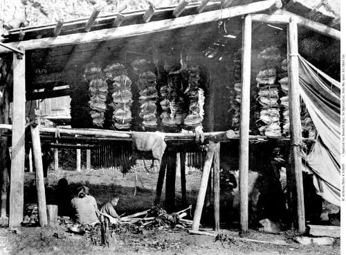
Stone wall fishing structure being used near Hagwilget, LowerBulkley River just upstream of confluence with Skeena River at ‘Ksan and Gitanmaax, Wet’suwet’en Territory, ca. 1910. Source: BC Archives https://goo.gl/EKKB2S

This post is just a random collection of lesser-known historic images of fish weirs and traps from the Northwest Coast and Interior. There’s lots to learn for archaeologists from historic pictures generally, but the way that images circulate and are reproduced means we often see the same ones over and over again. I’ve found a few archival pics which may be familiar to some, but possibly novel to many.

For example, the picture above shows a surprisingly large (to me) stone weir near Hagwilget Canyon, which is a major fishing station on the Bulkley River. I think it must be in the large kidney-shaped pool just downstream of the bridge (map). While the main structure may be partially or wholly a natural cobble bar feature, to the left there is a smaller weir that definitely appears cultural. Note the drying structures and smoke houses in the background, detail below.

Drying fish in structures at Hagwilget, ca. 1890s. Source: BC Archives https://goo.gl/4aAy6w

Drying fish in structures at Hagwilget, ca. 1890s. Source: BC Archives https://goo.gl/4aAy6w

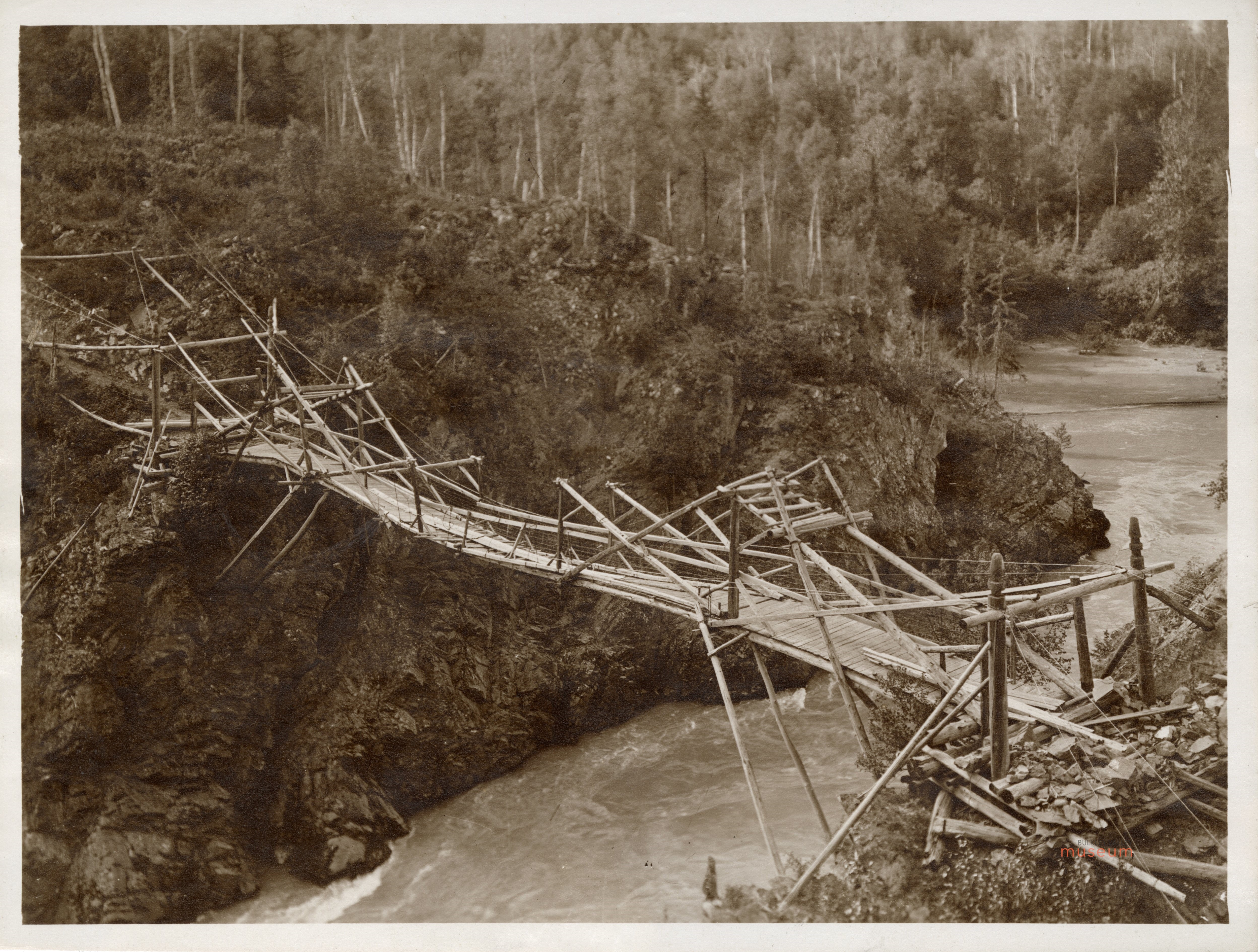
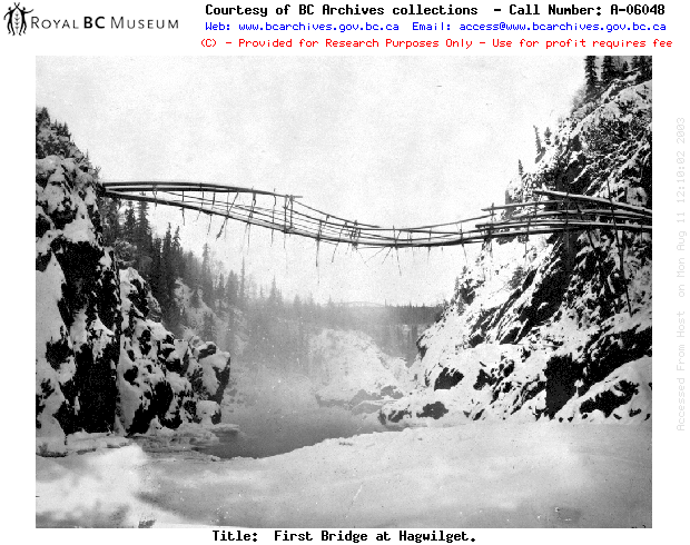
We discussed  Hagwilget once before when looking at the incredible bridge which used to span the river.  At that time I complained about copyright claims, and my opinion still holds when it comes to material digitized by public agencies. Anyway, the successor to the original Hagwilget bridge  bridge was not much more reassuring, and even the present day bridge is pretty hairy for the faint of butt.  Continue reading

Jarring Finds

Tom Beasley with olive jar from seafloor near Langara Island. Source: Northword Magazine.

Tom Beasley with Spanish olive jar from seafloor near Langara Island. Source: Northword Magazine.

One great thing about not keeping up with a blog is so much stuff accumulates like lint in the internavel that it is easy pickings to get material to post . . . . for example, the not very well known discovery by a fisherman of a Spanish colonial olive jar fragment in the waters off northern Haida Gwaii.  There is a nice summary by Jane Stevenson of the find in a 2012 issue of Northword Magazine, and much more information in an open access 1992 article in BC Studies.

The latter article by Hector Williams et al. has some interesting tit-bits, such as that the jar has a nippled bottom. But I digress….. Continue reading