The Midden, Reborn

Cover, Volume 1, Number 1 (Nov. 1968) of the ASBC newsletter, soon to become The Midden.

Cover, Volume 1, Number 1 (Nov. 1968) of the ASBC newsletter, soon to become The Midden.

As many readers will know, The Midden is the newsletter and journal of the Archaeological Society of B.C. The ASBC has fallen on some hard times in recent years with the Nanaimo Branch and the Vancouver Executive Branch both falling by the wayside. Luckily, the Victoria Branch, in recent years largely run by Graduate Students out of the Archaeology Lab at the University of Victoria, has retained its vitality and, after a hiatus and some thin issues, has recently started producing The Midden in its full glory again.

Even better news, the entire back run of The Midden since its first issue in 1968 is now available open access and online, with the exception that the most recent six months will be available to members only. It is to the enormous credit of the Victoria Group, who I have occasionally observed in their toils from faraway perch in Blog World Headquarters, that the ASBC and The Midden continue to express the vision of its founders over fifty years ago. The core group of the Victoria ASBC in recent years has including longtime members Pete Dady, Tom Bown and the late Gerry Merner, and more recently (and spearheading the digitization project) Jacob Earnshaw, Nicole Westre, Cal Abbott, Seonaid Duffield, and Colton Vogelaar (recent UVIC grads), and Genevieve Hill of the RBCM. Thanks also to the UVIC Library for hosting the journal. (If I’ve forgotten someone then apologies, and I will add them, just let me know). The ASBC has always been run by volunteers and has played a huge role in public education and promotion of archaeology in the Northwest, so the long-standing members and volunteers should also be thanked – of particular note perhaps, long-standing editor in the 1980s and 1990s, Kathryn Bernick.

Continue reading

The Rough Guide to the B.C. Gold Rushes

Anderson's map Kamloops area 1858. Note R. aux Chapeaux (Hat Creek) and R. de la Cache (Cache Creek to west; Shushwap Lake (Kamloops Lake) and the North Branch (of the Thompson River).

Anderson’s map of the Kamloops area 1858. Note R. aux Chapeaux (Hat Creek) and R. de la Cache (Cache Creek) to west; Shushwap Lake (Kamloops Lake) and the North Branch (of the Thompson River). Kumcheen / Little Fork, just upstream of Spence’s Bridge at the Nicola – Thompson confluence, lower left.

There were a lot of ways to make money from the B.C. Gold rushes which started in the mid 1850s. One of these was to publish a guide book to help prospecters enter the Gold Fields from starting points at The Dalles on the lower Columbia River or at Fort Langley, east of present-day Vancouver. Few were better prepared to write such a guide book (price: $1.50) than Alexander Caulfield Anderson, who had at least a decade of experience surveying for accessible routes into the interior of BC, especially Brigade Trails along which horse trains could pass.

The Gold Rush was, of course, one the of the main spearheads of colonialism and instigated or continued a lot of painful dispossession of Interior First Nations.  Anderson’s guide, available online (lower resolution 20 meg PDF direct download) can be read in many ways, but it is a valuable document of a slice of time (it is dated May 3rd, 1858, a watershed year in the history of B.C.), just as the middle Fraser Gold Rush was gaining steam but before the Cariboo Rush of the 1860s. It’s a pragmatic guide that gives landmarks, travel times, names of First Nations’ villages, where to catch sturgeon, how to hire a canoe, and other practical information and, of course, it includes an interesting map on the last pages, showing overland routes into and around the Interior.

Continue reading

Compilation of Work from Tse’K’wa (Charlie Lake Cave)

Cover of TseK'Wa Site Compilation, downloadable from Simon Fraser University

Cover of TseK’Wa Site Compilation showing “fluted point’ – the document is downloadable from Simon Fraser University

Charlie Lake Cave, also known as Tse’K’wa (the Rock House), is one of the best known archaeological sites in Western North America. Lying in the far NE of British Columbia, it containins a “fluted” projectile point, evidence of bison and small mammal/bird hunting, and shows basal dates of ca. 12,500 years ago. For decades it has been a key link in the understanding of the post-glacial occupation of the Americas.  It lies in the “Ice Free Corridor” which is a major focus of continuing research into the earliest periods in North America, and while the situation is very much unresolved, its safe to say that not everyone thinks the corridor was the route of first peoples into the Americas

It’s very cool and welcome, therefore, to see that many of the major scientific papers from this site (many authored or co-authored by Knut Fladmark and Jon Driver – two of B.C.’s pre-eminent archaeologists) are now downloadable for free from Simon Fraser University. The download is on this page, which contains a link to a PDF or an ePUB – but be aware that the PDF is about 100 megs.

The download itself is not the only cool thing of note here, though.

Continue reading

ASBC Victoria November 21st Public Talk: Underwater Survey for Late Pleistocene Archaeological Sites, Haida Gwaii

Autonomous Underwater Vehicle on surface of Juan Perez Sound, Haida Gwaii, with Parks Canada support vessel behind.

Autonomous Underwater Vehicle on surface of Juan Perez Sound, Haida Gwaii, with Parks Canada support vessel behind.

With sea levels rising by at least 120m globally at the end of the last ice age, conventional archaeological wisdom has been that sites on ancient coastlines are now deeply drowned. As is so often the case, conventional wisdom is over-simplified.  The B.C. coast is a good example, since the effect of ice weighting in some places counterbalanced the lower sea levels, meaning significant chunks of the coastal plain and paleo-coastlines were never-drowned.  Nonetheless, the underwater environment off the west coast doubtless contains thousands of early-period archaeological sites. Looking on land is more convenient, easier, cheaper, and allows one to breathe air – all good things. But looking underwater has some attractions too: methodological challenges, modelling issues, thinking about human life on a shrinking landmass, and a ridiculous amount of media coverage. The last is particularly important to University Administrators. Anyway, this month’s ASBC Victoria talk (poster, PDF) is on a project from a couple of years back which focused on attempting to find a particular kind of archaeological site on the sea floor: drowned fish weirs, especially rock wall ones, starting from the premise that such sites, which are often substantial in size,  should be confined to stream channels and might be directly visible to sidescan sonar.  For more information on the talk, click below.

Continue reading

The BC Archaeology Forum is Almost Here – Kamloops, November 18 & 19, 2017

Screen Shot 2017-11-09 at 10.24.49 PM.png

Blogs are so old fashioned and slow that I am sure you have all already heard of the when and where of the 2017 BC Archaeology forum – but I was asked to post a reminder and so here it is (it’s more than 144 characters so take a deep breath):

The Secwepemc Museum and Heritage Park and Tk’emlups te Secwepemc, welcomes the BC Archaeology Forum 2017 on Saturday, November 18th at the Moccasin Square Gardens (old KIRS Gym, Kamloops Indian Band). Saturday the 18th is reserved for a full day of speakers and presentations, followed by an evening event. Attendants are also invited to attend the Repository Roundtable discussions on Sunday Nov 19th.

It appears that you can still propose a paper, according to a nice email I got from one of the organizers (thanks, Carryl!).  It looks like you can get full information on the web here, or on facebook here.

The forum is usually one of the best ways to get up to date on new finds and issues in BC Archaeology, and is one of the rare events where First Nations Cultural Specialists, Cultural Resource Management Archaeologists, Academic and Student Archaeologists, and Government Archaeologists all get together in one place and at one time to compare notes. Looks like questions can be sent to bcarchforum17 [at] gmail.com, or see the poster below for an additional email.

Arch Forum Poster

ASBC Victoria, September Meeting: The Spanish at Yuquot: Santa Cruz de Nutka

Screen Shot 2017-09-24 at 11.51.20 PMThe Archaeological Society of BC winter lecture series kicks off this Tuesday September 27th at the University of Victoria, with a talk by Dr.Pablo Restrepo-Gautier from UVIC’s Department of Hispanic and Italian Studies.  Note that the talk is in a new room compared to last year: Cornett A129 – same building but on the south side.  The text of the invite is below.  The talk is free and open to the public.  Prior to the meeting the ASBC will hold a short AGM.

Details of the talk are below: Continue reading

The BC Archaeology Survey

Republic of Archaeology, B.C. Archaeology Survey, 2016.

Republic of Archaeology: B.C. Archaeology Survey, 2016.

There’s a survey being taken of BC Archaeologists, First Nation, and other interest groups such as museum professionals, realtors, developers, and interested members of the public.  it’s a fairly detailed survey with some quite specific questions about the regulatory and legal process of Archaeology and “Cultural Resource Management” in BC. The survey is run by Joanne Hammond, M.A., an archaeologist based in Kamloops, who also runs the Republic of Archaeology website, which is worth a look in its own right.  The survey is only open for another 10 days or so,until December 31st.

I took the survey a few weeks ago and I expect if there is sufficient participation then the results will be quite revealing about the present and future of the practice of Archaeology in B.C.  If you’ve read this blog much (not that it is getting updated, but still) you’ll know that the context of Archaeology in BC often becomes quite political, and charged with structural as well as unintended conflicts of interest, or the appearance thereof. Working in the colonial landscape we know that those “who control the past” assume upon themselves a lot of power and influence. Is the way that archaeology happens in this Province – almost always in a relationship to development – the best it could be?  Take the survey to add your voice.

ASBC Victoria Talk: Dr. Duncan McLaren on Late Pleistocene Intertidal Archaeology on the Central Coast of BC

calvert-footprints

Footprint (left) enhanced in purple right from the intertidal zone excavations at Calvert Island. Photo and enhancement: Joanne McSporran

This months Archaeological Society of BC monthly lecture in Victoria should be excellent.  Sorry for the short notice but it is tomorrow, Tuesday 18th, at 7.30, at UVIC.  Details below or on this PDF.  It is free and open to the public.

Hakai Institute Scholar and UVIC Anthropology Assistant Professor Dr. Duncan McLaren will be outlining some of the incredible finds from his Hakai Ancient Landscapes Archaeological Project (HALAP). Duncan set out to find early period sites on an area of the coast with relatively little long-term sea level change, following on from his highly successful UVIC dissertation research in the Dundas Group.  The area chosen for the new project was the Hakai Pass / Northern Calvert Island area, not far from the well-known archaeological site of Namu. Duncan will present some of his results, including newly investigated sites with more than 11,000 years of continuous occupation, intriguing lithic and other finds from the intertidal zone, and most intriguingly perhaps, a series of footprints from the intertidal zone which may well be terminal Pleistocene in age – perhaps more than 13,000 years old.

The research was carried out under the generous funding of the Hakai Institute and their Calvert Island research station, and with the active participation of the Heiltsuk and Wuikinuxv First Nations.

Details: Tuesday, Oct 18th , 7:30, Cornett B129, UVic Campus, Victoria. Map.

Duncan takes notes while Daryl Fedje works in the intertidal zone at the footprints site. Photo credit: Joanne McSporran

Duncan takes notes while Daryl Fedje works in the intertidal zone at the footprints site. Photo credit: Joanne McSporran

These Outer Shores: A special edition of BC Studies

Screen Shot 2015-11-08 at 7.47.48 PM
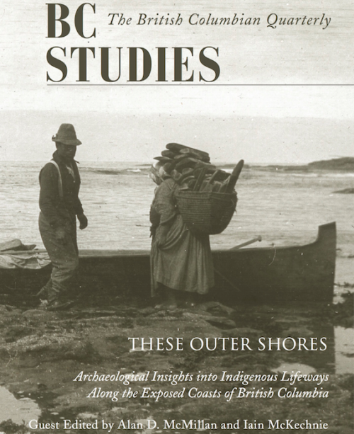
The regional journal BC Studies has a new special issue out focused on local archaeology. Entitled These Outer Shores, the edition is available for a reasonable price (20$) and two of the articles plus the forward are already open access, with the rest to follow in a couple of years.  The publisher’s blurb gives a good sense of the edition:

Guest Edited by Alan D. McMillan and Iain McKechnie, These Outer Shores presents recent archaeological research along the outer coast, from southeast Alaska to the entrance to Juan de Fuca Strait. The authors challenge the long-held perception of the western edge of British Columbia as “peripheral” or “remote,” removed from major cultural developments emanating from more interior locations. Instead, recent fieldwork and analyses document a lengthy and persistent occupation of the outer shores over the past 13,000 years. Using a variety of modern approaches and techniques, the authors examine such topics as changing sea levels, human settlement history, fish and shellfish harvesting, whaling, and the integration of Indigenous oral history with archaeology.

Continue reading

Glaciers brought mountain to man (not really)

Dionisio Point. Main vlillage sites in central upper portion of image. Credit: Colin grier via NPR.

Dionisio Point, north end of Galiano Island. Main vlillage sites (DgRv 6) in central upper portion of image. Credit: Colin grier via NPR.

A couple of months ago you may have heard of an exciting new study on the sources of rock for making stone tools in the Salish Sea.  “Glaciers brought mountain to man“, the headlines said, affirming that archaeologists working on Galiano Island had found nodules of raw material, not yet worked into tools, from the Mt. Garibaldi area of the lower mainland.  If, like me, you have a rudimentary knowledge of Salish Sea archaeology, you probably leapt to the conclusion that the raw material would be from the Garibaldi obsidian source.  So, cool: the mountain moves to Mohammed after all.  But, despite my being fairly disapproving of both sobriety and thinking in general, sober second thought did have me wondering: is it even possible that glaciers carried raw material from Garibaldi to Gabriola?  And from the relatively small and isolated high-altitude obsidian sources to a prominent village site?  ” It was brought there by glaciers, conveniently, 12,000 years ago”, the article asserts – thousands of years past the local ice maximum.  It didn’t easily compute. Luckily I was emailing with one of the paper’s authors, Dr. Colin Grier from Washington State University, and he set me straight on how the new article came to have something of a misleading takeaway point, while shedding some light on his recent interactions with the press.

Continue reading