Tag Archives: Heiltsuk

Stone Foundations and Tent Platforms in NW Coast Archaeology

Tlingit house with stone wall foundation near Juneau, Alaska.  Source: SHI Archives, Richard Wood collection. http://goo.gl/hH9Pfl

Tlingit house with stone wall foundation. “Photograph of a Taku village homes, photo likely by Partridge, circa 1887. Village site was located on the mainland across from Douglas Island, south of present-day Juneau”: SHI Archives, Richard Wood collection. http://goo.gl/hH9Pfl

We’re a little obsessed with wooden architecture in the NW Coast archaeology world – with good reason, I guess, since monumental wooden houses are such a prominent feature of the recent past. I suppose we sometimes stereotype these houses a little – a point some commenters made in the Houses on Stilts post here a while back – we think: “large rectangular house squatting in midden supported by giant house posts.” Not always the case, certainly not through time.

In general, we may underestimate large scale constructions in stone.  Burial cairns and mounds (one of Darcy’s consists of 18 dump-trucks worth of soil), rock wall defensive sites, trench embankments, canoe runs, fish traps, and of course, clam gardens, all involved massive deployments of stone, with associated labour investments and creation of a durable built environment. Anyway, we’ve recently been running into enigmatic rock structures on the central coast and Quadra Island, and in particular, the possibility of dwelling structures partially based on stone walls.  So it’s quite cool to run across the picture above from the SHI photo collections, showing a Taku Tlingit house from the historic period, sitting on a platform which has a stone wall as a foundation.

Continue reading

Visit to the UNBC Fieldschool on Calvert Island

Deep unit at ElTa-4, Calvert Island.

Deep unit at Luxvbalis, EjTa-4, Calvert Island.

This blog’s world headquarters has temporarily moved out to the central coast, where yours truly is tagging along with Dr. Duncan McLaren and his team working on the early period archaeology and landscape history of the Hakai area.  The project is sponsored in very generous style by the Hakai Beach Institute, which also funds and facilitates a variety of research on the cultural and natural history of this beautiful and sensitive area. One of the other Hakai projects is an archaeological fieldschool directed by Dr. Farid Rahemtulla of the University of Northern BC.  I wrote about this fieldschool once before and you can get some background on this site (EjTa-4, Luxvbalis) at that link. The site is in the traditional territory of the Heiltsuk and Wuikinuxv First Nations.  Yesterday I had the chance to visit the site, get shown around by Farid, and hang out at the screens with his great students – and to be the annoying guy with a camera.

So it’s a really deep site.  Above you can see Kira Cari in this years main excavation unit.  They are expanding a unit from last year which went down 4.7 metres or so without bottoming out. As of yesterday, they are about 2.4 units down.  Basal dates so far are in the 6-7,000 year old range but this might get older since the bottom is not yet reached and there may be older cultural deposits intact in the intertidal zone as well. Continue reading

Weir on the River Koeye

Building Koeye Weir. Photo by Grant Callegari via indiegogo.

Building Koeye Weir. Photo by Grant Callegari via indiegogo.

There’s a pretty amazing new construction on the  on the Koeye River (pronounced roughly “kwaay”) on the central coast of B.C. (map).  A team has built a traditional style wooden-weir across the river, and are using it for fishery management – trapping, counting, measuring, and gently releasing salmon at the end (and start) of their life cycle. The construction has been documented at the willatlas.com blog, including some amazing photos, and there are posts on the Hakai Beach Institute blog as well. Even better, there is a short documentary.  This is actually is a teaser for a longer documentary, which is in the fund-raising stage, and I don’t mind using this blog as a platform to bring this really great project to people’s attention.  You can see their fundraising page here.

Continue reading

ASBC Victoria – Public Talk Tue Nov 15th: Duncan McLaren on Early Archaeology of the Central Coast

Duncan McLaren using Livingstone core on Castor Poop Lake on Porcher Island, B.C.. Daryl Fedje holds the leash.

Next up for the local (Victoria) branch of the Archaeological Society of B.C. is a Tuesday, November 15th talk by Dr. Duncan McLaren of Cordillera Archaeology and the Anthropology Department at University of Victoria.  Duncan’s highly successful  Ph.D. thesis was an interdisciplinary, geoarchaeological approach to the early occupation of the Dundas Island group on the northern B.C. coast. He is now in the early stages of applying a similar research program to the Central Coast of B.C., which promises great advances in knowledge.

The talk is free and open to the public, and you don’t need to be an ASBC member to attend.

Early Period Archaeology and Landscapes on the Central Coast of British Columbia

November 15th, 2011, 7:30 pm
Pacific Forestry Centre,

506 West Burnside Road (Map)

FREE AND OPEN TO THE PUBLIC.

Namu Reburials

SFU Archaeology instructor Rudy Reimer holds a small replica of the handmade bentwood boxes that will be used to store ancestral Aboriginal remains. Source: SFU flickr stream.

There have been several newspaper stories recently noting the impending repatriation and reburial of human remains excavated from the famous Namu village site of the Heiltsuk Nation, on the central coast of B.C.   For example, here is one from the Vancouver Sun (PDF), another from the Globe and Mail (PDF) and a media release from Simon Fraser University itself, whose archaeology department conducted most of the excavations at this large site in the 1970s and 1980s, mainly under the direction of Roy Carlson. As ever, each newspaper source contains slightly different information.

Continue reading

Old site on Calvert Island, Central Coast of B.C.

UNBC student Cory Hackett excavates a unit in shell midden (photo credit: B. Alway, via UNBC)

There’s a good, recent article in the Globe and Mail (PDF) on some exciting preliminary findings by Dr Farid Rahemtulla of UNBC at a site on Calvert Island (map).

The site, thought to be the “lost village” of Luxvbalis, is in territory of the Heiltsuk and Wuikinuxv (formerly Oweekeenow/Awikenox) peoples.  The project was intended to re-locate this village, which figures prominently in Oral History.  Continue reading

Arborglyph

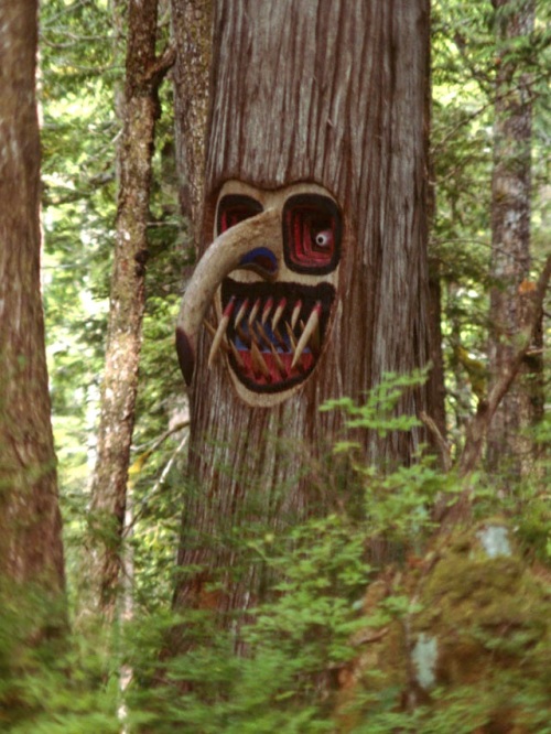
calvert island face

Carved face on a Calvert Island tree. Photo: Dan Leen.

I’ve mentioned Dan Leen’s excellent web page before.  When I was on Teredo N. with him I heard many excellent stories including how he came across a spectacular carved tree on Calvert Island, near Namu.  Finally I get to see what he meant.  This strikes me as the work of a trippy bush hippy (and maybe Dan himself, heh) more than a NW Coast thing, but it is fun nonetheless.

Incidentally, “Arborglyph” is a Frankenstein word melding Greek and Latin roots and should probably be replaced with “dendroglyph”, which is also easier to say.

Single Hook

Pomeroy polynesian hook 1

Polynesian-style fish hook found at McNaughton Island

John Pomeroy found this unusual shell (“scallop”) artifact at McNaughton Island (ElTb-10) on the central coast in 1972 (Pomeroy 1980: 321b).  It strongly resembles some Polynesian fish hooks, and is also similar to some Californian ones.  While no scale is given, by comparison to the text it appears about 5 cm long by 4 cm wide. Pomeroy offers three suggestions:

Pomeroy polynesian hook 2

Polynesian fishook from Beasley (1928) via Pomeroy (1980)

1. That it was traded from California

2.  That it was brought from Polynesia by early European explorers.

3. That it arrived inside a tuna.

He notes that there are no tuna remains at this site, which makes (3) less likely though not impossible.  While trade from California is possible, Pomeroy  notes that this specific artifact most closely resembles some from Polynesia and not from California – namely the one to the right from Beasley (1928).  The fact that it was found at a depth of 1.7 metres suggests that (2) is unlikely.  There is a date for about one metre below the surface at this site of 900 BP.  While the exact relationship of the date sample to this artifact is uncertain on my brief reading, it is most likely the date is above the artifact and thus more recent.  Certainly this general time frame of less than 1500 years is the time when eastern Polynesia is being settled and there may have been greater opportunity for drift items or other accidental contact to occur.  On the other hand, this is also said to be the time that the Californian examples arise.

Pomeroy leaves the matter unresolved.  I’m going to keep my eyes open for other examples including fragments that might be misclassified.

polynesian fishhooks

Polynesian Fish Hooks.

The Brooklyn Museum Collection

Tsimshian Skull "Helmet".  Click for higher resolution.

Tsimshian Skull "Helmet". Click for higher resolution.

Of all places, the Brooklyn Museum has amassed an impressive suite of NW Coast artifacts and art.  Their online catalogue is mainly lodged under the  “research” and “collections” tabs.  One interesting thing about this collection is that any viewer can ‘tag‘ a picture, building up a folk taxonomy that cross-cuts more traditional museum categories.  This has its advantages of course (e.g., items which are tagged “beards“, or “scary“), but also raises questions about just how comprehensive is any set of results?  And how accurate – this rattle is tagged Tsimshian despite being collected in Bella Bella (Heiltsuk territory).  Still, with a grain of salt it is an idea definitely worth pursuing.  You can also click around on their “visible storage” map.  The images are decent resolution and combined with the tag-surfing possibilities this is a fun and informative site.

Heiltsuk Ladle with Skull. Click for larger resolution.

Heiltsuk Ladle with Skull. Click for larger resolution.

dSpace: Elroy White (Xanius) on Fishtraps

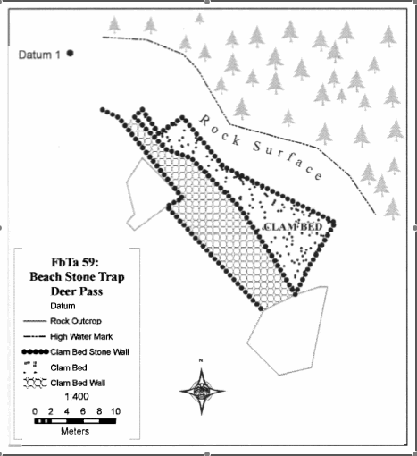
FbTa 59, a possible clam garden on the central coast.

FbTa 59, a possible clam garden on the central coast. Source: Elroy White / Xanius M.A. thesis.

I’ve only met Elroy once or twice but he seems like a sharp guy and I was looking forward to reading his 2006 thesis, which turns out to be an exceptional work – ambitiously trying to implement Eldon Yellowhorn’s “internalist archaeology” in his home territory (Heiltsuk) on the central coast.  This project, which focuses on fishtraps, is exemplary in a couple of ways.  First, as a cutting edge exercise in the practice of archaeology, indeed, practice as theory.  The combination of field archaeology, internalist work with a dozen elders, and extensive videography was a great exercise.  (PS Elroy, post some videos!).   Second, well, fishtraps are exceptionally interesting and need more study.  Essentially, we are just guessing about the specific functions and efficiencies of these features.  Elroy gathers a lot of information from elders, including interesting longitudinal data showing how quickly these features silt up — evidence in some ways for their silt retention qualities and also a suggestion there may be a lot of partially or totally obscured fishtraps out there.  And, as above, Elroy appears to find some “clam gardens” (diagram) in Heiltsuk territory.  Maybe it’s because my doctoral SSHRC project was going to be on fishtraps until I got talked out of that and into a GIStraightjacket, but I love’em.  Anyway, you can get yourself a copy of this high quality MA theses here, at SFU dSpace.

Incidentally, for an earlier, wider scope take on subsistence and settlement and fish traps on the central coast, you can also download John Pomeroy’s 1980 PhD thesis (which doesn’t show up under “archaeology” in their classification or keyword scheme for some reason.)

Elroy White (Xanius) with intertida fishtraps.  Credit: Ecostrust Canada.

Elroy White (Xanius) with intertidal fishtraps. Credit: Ecotrust Canada.