Tag Archives: waterlogged sites

ASBC Victoria Talk: Tuesday September 16, Jenny Cohen on Paleoethnobotany of Kilgii Gwaay

2002 excavations at Kilgii Gwaay Site.

2002 excavations at Kilgii Gwaay Site.

Paleoethnobotany of Kilgii Gwaay: a 10,700 year old Ancestral Haida Archaeological Wet Site

Jenny Cohen

Tuesday, September 16, 2014, 7:30 pm

Cornett Building B129

(North End of Cornett building)

University of Victoria (map)

The Victoria Chapter of the Archaeological Society of BC (ASBC) has a long-running monthly Fall-Spring speaker series which is starting again next week.  The speaker is UVic Anthropology graduate student Jenny Cohen, speaking on results from her paleobotanical analysis of the 10,700 year old intertidal wet site, Kilgii Gwaay, in southern Haida Gwaii.  It’s a fascinating site which gives real insight into the way of life of Ancestral Haida at the Pleistocene-Holocene transition and I’m sure Jenny’s thesis, nearing completion, will be of wide interest.

If you don’t have enough Kilgii Gwaay in your life then I recommend you jump over to the Burnt Embers blog, where there are some excellent photos from the tricky intertidal excavations at that site a few years ago: Setting Up;  Keeping Water Out; Putting Water InWater Screening; and Kilgii Gwaay Finds.

Abstract: Continue reading

Final Qwu?gwes wet site report is available for download

Toy war club from Qwu?gwes site.  Source: Qwu?gwes Report.

Toy war club from Qwu?gwes site. Source: Qwu?gwes Report. Click to enlarge.

Dale Croes kindly sent me a link to the final report for the Qwu?gwes wet site (45TN240), which is  is located on Mud Bay at the southern end of Eld Inlet, Puget Sound, near Olympia, Washington (map). The site was apparently first occupied about 800 years ago.  This report, hosted at NewsWARP, checks in at almost 1,000 pages and about 80 megs, and is the product of more than 10 years of field-school and collaborative research with the Squaxin Tribe.  There look to be about two dozen authors. If you’re not up for the whole thing right away,  there’s a much shorter executive summary you can download here. But it’s a really impressive report covering everything from stone to bone to wood, bark, root, wood I.D., ethnobotany, paleo-seismology, fishtraps, and more.  It’s very clearly written at an accessible, non-technical  level, largely by students. I’ll pick out a few of many highlights below. Continue reading

Anchor Stones

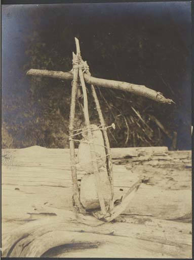
Duwamish composite stone anchor. Source: UW.

Edit October 2018: Hoko Pictures are now here.

I was talking the other day about how under-represented organic technology is in archaeology generally, and especially on the Northwest Coast, where the old adage is that 95% of the technology was made out of plants (trees, wood, bark, roots, grasses, seaweeds).  A classic example of this phenomenon are anchor stones and sinker stones.  While some of these stones had grooves or perforated holes (and are thereby very visible and durable in the archaeological record), many may have been made by the more simple, subtle and expedient method of simply wrapping line or basketry around an unmodified rock.  When the organic component rots away, as it will most of the time, then the archaeologist has, well, an unmodified rock.

Anyway, it was a lucky stroke for my current interest that I came across the above photo from the University of Washington Digital Archives.

Continue reading

ASBC Victoria – Public Talk Tue Oct 18: Daryl Fedje on Gulf Islands Archaeology

Parks Canada - UVIC Archaeological Project in the Intertidal Zone, 2010.

Next up for the local (Victoria) branch of the Archaeological Society of B.C. is a Tuesday, October 18th talk by Daryl Fedje of Parks Canada Archaeology. Details below; it is free and open to the public.  I know of some of this research to be presented and if I can add an editorial comment:it is now clearly demonstrated that the intertidal zone has very high potential for un-disturbed archaeological deposits, some of which show exceptional preservation.  These include not only classic “waterlogged sites” with woody preservation, but also numerous water-saturated shell middens, and even the remains of intact house features.  I think it’s probable that in the Salish Sea at least, the intertidal zone is a hugely unappreciated zone of interest and I hope the Archaeology Branch and Consulting Archaeologists are working together to make sure it gets a thorough examination. And, if they aren’t, then it would be welcome if First Nations were to apply pressure by demanding routine subsurface testing in intertidal zones as a minimum requirement for shoreline archaeological assessments, perhaps commenting to this effect when reviewing permit applications.  Anyway:

Intertidal Archaeology in the Gulf Islands National Park Reserve

October 18th, 2011, 7:30
pm Pacific Forestry Centre,
506 West Burnside Road (Map)

FREE AND OPEN TO THE PUBLIC.

Abstract:  Recent investigations in the Gulf Islands National Park Reserve included a focus on the intertidal zone. Analyses of cultural and paleoecological data obtained from these investigations has resulted in a more detailed sea level history for the area and, discovery of a suite of archaeological sites associated with sea levels slightly lower than modern. These now-intertidal sites include intact shell middens and apparent house features dating as early as 4,000 years ago.

Bio: The Victoria ASBC Branch president writes,  “Daryl Fedje is a long-time archaeologist with Parks Canada, now based in Sidney, B.C.  He is widely published, with a respected international reputation.  Research in the Gulf Islands that he directs, co-directs, or facilitates is some of the most current work relevant to the Victoria region – but of course with wider ramifications.

Glenrose Cannery Under Threat?

Anthropomorphic and zoomorphic sculpture from Glenrose and St Mungo Cannery sites. Source: Delta heritage passport

The Glenrose Cannery site, which lies on the Fraser River near the Alex Fraser bridge, is one of the mose significant archaeological sites in BC.  The human figure on the left, above, dates to the ‘St Mungo” phase, putting it at between 3500 and 5000 years old.  It might be the oldest known representation of a human being in British Columbia – well, to my knowledge, it is.  Yet, you can already see elements of the formline art appearing – look at the eyebrows, for example.  More importantly, look at the beard.  Look at the hair, pulled into a bun.  This is a portrait of an individual.  The artifact, which is probably a small handle for a chisel, is a masterpiece of Canadian art. The site in which it was found shows continuous occupation from the present to about 9,000 years ago and spans up to eight metres of vertical deposits.

So it is disturbing to think that Glenrose might be further affected by development, in this case, road building associated with the “Gateway Project”, a transportation infrastructure megathrust to get stuff to and from the Ports of Vancouver faster. There is a short article in The Province yesterday (archive) in which UBC Professor Emeritus RG Matson, one of the key figures in BC Archaeology, visits the site.   We can’t preserve everything from the past, clearly, or all cultures at all times would have been glued to the footprints of their forebears.  But a site of such demonstrated significance as Glenrose should probably be completely off limits.

Continue reading

Hoko River pictures are back

Hoko River project director Dale Croes, apparently wearing chaps, at the site in 1977.

(Edit 2018 October: look here for current location of these pictures)

Some time ago I pointed readers to the vast repository of Hoko River wet site excavation pictures put online by Dale Croes.  Unfortunately, those links broke but now, via  blog reader APM, I hear that the Hoko photo gallery is back online.  I will definitely be mining this repository for lots of posts.  Not only is this one of the most interesting sites ever excavated on the Northwest Coast, the pictures are a superb combination of excavation, artifact, and camp life – the latter a visual record of local archaeology as social practice in the 1970s. Also, as I mentioned previously, the lush, rich colour of the old Kodachrome slide film is stunning – you just don’t see that in modern digital cameras or even print film, despite the undeniable advantages of digital.

From the main page, many of the most interesting pictures are found under the “camp life” link.  There you will be confronted with an awkward frames-based link layout.  Not all links work still, but I’d say 90% do.  You can browse easily by clicking on the pictures that open on the right-hand frame to get the next picture.  This is easier than keeping the mouse centred on the picture number to the left.  Right click on the picture to bring it up in its own window or tab.  Some pages are organized as thumbnails, such as the wet site stratigraphy series. Because of the slightly awkward interface, I’ll aim to create a series of posts here which point to what I think are interesting aspects of this wonderful site.

Richard Daugherty and survey crew evaluate potential of Hoko Site in 1967 in WSU research vessel.

Ancient Basketry from the Biderbost Site

2,000 year old basketry from the Biderbost Site, Seattle. Source: Burke Museum.

The Biderbost site is on the Snoqualmie River near Seattle.   Since 1960, a series of excavations have revealed a remarkable set of artifacts made from organic materials, preserved because of the water-saturated, anaerobic conditions of deposition.  The Biderbost site was the first site of its kind to be excavated in the Northwest, at least to a professional standard.  The Burke Museum has an excellent page on this site, including a page of basket photos (reasonable resolution, yay), weaving techniques, and conservation of these delicate artifacts.  There are also three informative (if not exciting) videos on YouTube about:

These artifacts, which include a large number of basketry pieces, date about 2,000 years ago.  Since most archaeological sites in the Northwest preserve stone, shell and bone fairly well but not wood, bark or root, these sites (which also includes Ozette, Hoko River (pics now broken fixed), Pitt Polder, Qwu?gwes, Kilgii Gwaay, and others) offer remarkable insight into the organic technology.  Ordinarily, we don’t see this stuff at all archaeologically and yet it may be the majority of the traditional technology; it may be stylistically distinctive and different compared to stone and bone tools; and it may be disproportionately representative of the lives of women.

Why there aren’t more archaeologists focusing research questions on these sites is unclear to me: yes, they are awkward sites and expensive and time consuming, but then so are shell middens.  I suspect it boils down to the unfortunate fact that the key NW wet-site researchers in the last thirty years (Dale Croes and Kathryn Bernick) were never in the kind of academic position where they routinely supervised graduate students and hence they were never able to harness the energy and intellect of that backbone of NW Coast Archaeology: the Master’s student and their diverse and often excellent theses.

I would be remiss in not mentioning that the Burke Museum has a Biderbost “Adopt a Basket” program to help with long term conservation of this remarkable suite of artifacts.

Basket rim and body fragment from Biderbost. Note the mud embedded in the weave. Source: Burke Museum.

Fishing weight wrapped in basketry with sticks attached. At a normal site this would appear to be an unmodified pebble. Source: Burke Museum.

Memories of Ozette

Makah whaler Wilson Parker posing as a MAKAH WHALER for Edward Curtis, ca.1915

The magazine of Washington State University has a nice article on the archaeological project at Ozette, the UNESCO World Heritage Site on the west side of the Olympic Peninsula.  This Makah village site was covered by a landslide about three hundred years ago (animation), which created preservation conditions highly favourable to preservation of wooden artifacts.  The story begins

THERE’S A WELL-KNOWN PHOTOGRAPH taken by Native American chronicler Edward Curtis in 1915 of a Makah whaler. Dressed in an animal skin, the man is longhaired and wild. He had indeed been a whaler, as had generations of his people. But still, the photograph is a memory of a time already past. Curtis provided Wilson Parker with a hide and a wig to replace the European clothes the Makahs had adopted long before. In spite of Curtis’s fiction, however, there is much to be learned from Wilson Parker, the man in the photograph. As is always the case with a good myth, there is a deeper truth that lies beneath the surface story.

Parker is Sharon Kanichy’s great-great-grandfather, she tells me as we talk in the Makah cultural center in Neah Bay. Kanichy ’01 was born in February 1970. That same month, a powerful storm blew in off the Pacific, eroding the bank above the beach at Cape Alava, on the Olympic Coast, revealing something remarkable.

“All we knew was there was a burial site,” says Ed Claplanhoo of the buried longhouses revealed by that February storm. Claplanhoo ’56 was Makah tribal chairman in 1970, so it was he who got a phone call the first Saturday in February, from a hippie schoolteacher, as Claplanhoo describes him. A dubious character, says Claplanhoo, which is why he didn’t take the fellow seriously when he tried to warn Claplanhoo that “people” were getting in the “house” and taking “artifacts.” Claplanhoo knew everyone in Neah Bay and knew everyone who owned artifacts. He’d heard of no problems.

But the fellow persisted. The next Sunday, the same phone call. “Mr. Claplanhoo, they’re still taking artifacts out of the house.”

“So I said okay,” says Claplanhoo, “I’ll tell you what, you come to my house at seven o’clock tonight and we’ll talk about it.”

From there, the article recounts the story of the Ozette excavations from the point of view of both Makah and the archaeologist Richard Daugherty, who led the decade long excavation of “North America’s Pompeii.”  It nicely captures the importance of the site as well as the nature of the dig and the social relations formed which endure to this day.

Don’t miss the slideshow from the excavations — it’s an awkward interface but some very atmospheric pictures of life on a remote archaeological dig in the 1960s – as well as a few shots of the US Marines who helped airlift supplies in and treasures out.

Digging at the Ozette Site - the hoses were used to gently free the wooden artifacts, such as the house planks shown, from the mudflow which buried them. Source: WASU Magazine.

Photo Essay on the Qwu?gwes Site

EDIT February 22, 2010: Pictures removed after communication from Lee Rentz (see comments).

Dale Croes has been doing great work for years on wet site archaeology, most notably a long association with the Hoko River wet and dry sites on the Olympic Peninsula.  More recently he has spent a decade or so at the Squaxin Tribe’s Qwu?gwes waterlogged site near Olympia, Washington.  I see that Lee Rentz’s Photography blog has a nice photo essay on the Qwu?gwes site called Ghosts Dwell in the Lowering Tide.

Wet sites can produce locally anaerobic (oxygen depleted) environments, preventing or slowing bacterial degradation of organics.  This allows survival of many artifact types which rapidly deteriorate in normal archaeological settings.  At Hoko, there are well preserved wooden artifacts over 2,000 years old, at Qwu?gwes the material is mostly about 700 years old.  Similar sites elsewhere on the Northwest Coast are mostly  less than 5,000 years old, with the notable outlier of Kilgii Gwaay, which is 10,500 years old.  Since some estimates put wood artifacts at 90% or more of NW Coast technology, you can imagine how revealing these rare, and increasingly threatened, waterlogged sites are.

The photos at Lee Rentz’s blog are excellent, and the text is accurate and informative.  Good to see!  If you want to find out more, some scholarly and other articles can be downloaded here, or you can work at Qwu?gwes yourself as part of a field school.

Hoko River pictures

Hoko barbed wooden point.

Hoko barbed wooden point.

Edited Feb 17/2010: Fixed the broken links.

October 2018: Hoko pictures are now here.

So, a new school year beckons.  Erk.  As a distraction, treat yourself to the huge photo library of the Hoko River site which was put online by Dale Croes.  A few dead links in there, but some pictures of fantastic artifacts, plus a sense of the project unfolding – slug fest included, as well as a visit from Hoko Site patron and “Clan of the Cave Bear Author” Jean Auel. The pictures are dusty, scanned-in transparencies (I think) which retain sense of nostalgia and the quiet punchiness of colour us old farts remember as fondly as we do the occasional upside-down slide at conferences.   I’ll probably occasionally use the Hoko site as the basis for future posts here.  On the left, a substantial barbed wooden(!!) point from the 2400 year old wet site deposits.