Tag Archives: Vancouver Island

ASBC Victoria Tue Feb 19th: Coastal Archaeology in Huu-ay-aht territory, Vancouver Island

Archaeological work in Huu-ay-aht territory, 2012

Archaeological work in Huu-ay-aht territory, 2012

Quick note to say that the upcoming February meeting of the Victoria Chapter of the Archaeological Society of B.C.  should be a good one (sadly I am back east at the time):

Coastal Field Archaeology in Huu-ay-aht Territory: Highlights from the 2012 Bamfield Marine Science Centre Archaeological Field School

Tuesday February 19th, 2013, 7:30 pm Pacific Forestry Centre,
506 West Burnside Road. map

Free and Open to the Public

Abstract: In July and August of 2012, the Huu-ay-aht First Nation and the Bamfield Marine Science Centre co-hosted a ‘Coastal Field Archaeology’ course on Huu-ay-aht Government Lands in Barkley Sound on western Vancouver Island. Continue reading

More on Comox Harbour Fishtraps

Fishtrap stakes delineating chevron patterns in the intertidal zone of Comox Harbour. Photo credit: Greene 2010.

I posted once before some time ago on the incredible fishtrap complexes in Comox Harbour on eastern Vancouver Island, highlighting Megan Caldwell’s M.A. thesis (downloadable) on the topic, and mentioning in passing that primacy of investigation should perhaps go to Nancy Greene, who has been mapping and dating these features for about a decade.  I was glad to find the other day that Nancy Greene has a 2010 downloadable poster on the topic (link starts a 4 meg PDF)  from an academic conference: WARP, the Wetland Archaeological Research Project, which itself has a nifty new website.

These Comox Harbour fishtraps are one of the wonders of B.C. Archaeology and it is highly welcome to see some more of Greene’s reconstructions and mapping.

Continue reading

CRM problem at Englishman River

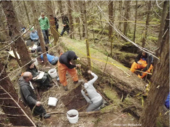
Excavation of house foundations at Englishman River. Source: CBC

Hmm, I just noticed today is the first anniversary of this blog.  Mind you, it was a slow and intermittent affair at first but with more regular posting has come steady increase in readership.

But you know who else had a birthday on April 20th?

With that in mind, what better way to celebrate than by checking out the firestorm brewing on the Englishman River, where some landowners, perhaps wilfully ignorant, have had an unfortunate series of events transpire regarding an archaeological site on their property. The Archaeology Branch has responded to the story with a terse memo.

A little background to start:

All archaeological sites in B.C. dating to before 1846 A.D. are protected under the Heritage Conservation Act.  This is true whether or not they are known to the Archaeology Branch or unknown and unrecorded.  In some ways, then, it is not relevant that the site under these people’s house was first recorded, I am told, in 1975.  Even if it was first discovered by the application of a backhoe in April 2010, it would be accorded the same protection under the law. The fact that the landowners claim to have not known about the site until recently is an interesting issue that does not really materially affect the facts of this case. And, under the standard procedures in place, they are indeed responsible for paying the costs of the archaeological investigations, in this case reported to be $35,000.  Whether or not they have the money also doesn’t affect the facts of the case – incidentally, these people who self-portray as poor and unemployed are finding archaeology because they are building a new house on their property, which must be costing them several hundred thousand dollars.

So, these facts may not actually alter the legal responsibilities, but they do however very strongly affect the way this issue is seen to be unfolding.

Continue reading

Waatch River: a raised beach site on the Olympic Peninsula

View from West up Waatch River Valley to Neah Bay; Vancouver Island in the distance. Source: Panoramio user Sam Beebe.

The Waatch River flows in a low valley that connects Neah Bay across the Olympic Peninsula to Makah Bay.  When sea levels were higher, it would flood with sea water and turn Cape Flattery into an island.  Interesting, then, to see that an old raised beach site has been found on the Waatch River at an elevation of about 13 metres above, and 2 km away from, the modern shoreline.

Continue reading

A Saanich Peninsula short-faced bear

Post removed by request.

Continue reading

Major expansion at the Royal B.C. Museum?

Proposed changes to the RBCM: the clear white structure to the back left is the new curatorial tower & archives; to the right is a new entrance and multi-functional area. Source: Times-Colonist.

The Victoria Times-Colonist had a story Saturday that the Royal B.C. Museum is proposing a major expansion, in which theirs quare footage would more than double, from 379,000 to 895,000 square feet.  The curatorial tower and the low-rise archives building on the NW side of the block would be demolished, replaced by a new multi-function complex which would also form the entrance to the museum.  The collections and curatorial facilities, and the archives, would move to a new 14 story building to the south of the current museum.  The RBCM C.E.O, Pauline Rafferty (an archaeologist by training) notes that ““We are now at a crossroads.  We have outgrown our on-site storage facilities and significant artifacts are stored below sea level.”  The article estimates the cost will be in the hundreds of millions of dollars which is easy to believe. The Times-Colonist weighs in with a strong editorial of support, citing the collapse of the Cologne archives last year with irreparable damage to the history of that City.  So: no-brainer, right?

Continue reading

dSpace: Dentalia Shells on the Northwest Coast

Dentalia Source "mu7is" in Hesquaht Harbour.  From Barton M.A. p. 116

Dentalia Source "mu7is" in Hesquiat Harbour. From Barton M.A. p. 116

Andrew Barton did an excellent job reviewing the biology of the Scaphopoda, the archaeological record of dentalia use and trade, and the technology available to harvest these small creatures with tusk-shaped shells.  Overall, he brought a lot of nuance to a topic that had been somewhat over-simplified.  For example, there is no real evidence that these shells were only available at depth from the NW corner of Vancouver Island.  Barton reports on attempts to replicate ethnographic dentalia “spears” (more like a rake, or a pasta fork).  You should be able to download a copy of Fishing for Ivory Worms : a review of ethnographic and historically recorded Dentalium source locations from SFU dSpace.

Dentalia necklace by Josephine Ingraham, Clatsop/Chinook Tribes

Dentalia necklace by Josephine Ingraham, Clatsop/Chinook Tribes