

Dixon’s 1787 map showing Haida Gwaii as an Island. Source: Library of Congress
Old Maps are Cool. Enough said. Or maybe not quite enough. Continue reading
Dixon’s 1787 map showing Haida Gwaii as an Island. Source: Library of Congress
Old Maps are Cool. Enough said. Or maybe not quite enough. Continue reading
Posted in archives, First Nations, Haida Gwaii, history, Northwest Coast
Tagged Captain Dixon, cartography, charts, Haida Gwaii, Haida Nation, maps

Downloadable Selections from the Online Catalogue of SFU Archaeology Press.
If you’ve been to virtually any archaeology conference in the Northwest in the past I dunno, 5 decades – then you know you can reliably find Roy and Maureen Carlson at the SFU Archaeology Press book table, and if you’re like me you’ve walked away with yet another copy of Papers on Central Coast Archaeology for yet another five bucks. Yes, they are that persuasive. Since some of the back catalogue was going out of print, it is great to see that for the last couple of years the entire publication run of SFU Archaeology Press has been freely available online. This includes publications ranging from the early 1970s to 2015.
Most local archaeologists are probably aware of this but it seems worthwhile to spread the word. Continue reading
Posted in Archaeology, archives, Miscellaneous, Northwest Interior, Northwest Coast
Tagged open access, Publications, SFU, SFU Press
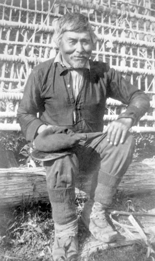
Old Enoch ca. 1910; was the builder of all fish traps; in the background is one he has just completed, made from young Jack pine and lashed together with wild rose roots. Source: BC Archives: https://goo.gl/uGtVo4
Not every blog post has to be an essay, sometimes we can just admire the slightly smug look on a smiling guy who is good at making fishtraps, and knows it. And obviously I’m kidding about the essay part.
Posted in Archaeology, anthropology, archives, First Nations, Technology, Northwest Interior
Tagged fish, fish traps, fishing, salmon, Skeena River, weirs

Detail of “Chief’s Regalia” 3-D model, Secwepemc Museum. Note how you can see the many layers of leather, fur and stitchng. Model by arck-project. https://sketchfab.com/models/bcacd91251954b2281e41b554d4db88d
While I was sleeping, 3-D digital models of archaeological items and features have come a long way in their usability and quality. I stumbled into a set of three cool models from the Secwepemc Museum & Heritage Park (in Tk’emlúps / Kamloops), who have collaborated with a company called The ARC/K-Project which uses SketchFab to make rotatable, high-resolution, and (most importantly based on my experience) slick, smooth, and stable virtual models of a few of the items in their collection, such as the Chief’s Regalia detail shown above (link to model). I was mildly disappointed that there were only a couple of 3-D models online, but then I found more. More is good, nom nom nom. Continue reading

Anderson’s map of the Kamloops area 1858. Note R. aux Chapeaux (Hat Creek) and R. de la Cache (Cache Creek) to west; Shushwap Lake (Kamloops Lake) and the North Branch (of the Thompson River). Kumcheen / Little Fork, just upstream of Spence’s Bridge at the Nicola – Thompson confluence, lower left.
There were a lot of ways to make money from the B.C. Gold rushes which started in the mid 1850s. One of these was to publish a guide book to help prospecters enter the Gold Fields from starting points at The Dalles on the lower Columbia River or at Fort Langley, east of present-day Vancouver. Few were better prepared to write such a guide book (price: $1.50) than Alexander Caulfield Anderson, who had at least a decade of experience surveying for accessible routes into the interior of BC, especially Brigade Trails along which horse trains could pass.
The Gold Rush was, of course, one the of the main spearheads of colonialism and instigated or continued a lot of painful dispossession of Interior First Nations. Anderson’s guide, available online (lower resolution 20 meg PDF direct download) can be read in many ways, but it is a valuable document of a slice of time (it is dated May 3rd, 1858, a watershed year in the history of B.C.), just as the middle Fraser Gold Rush was gaining steam but before the Cariboo Rush of the 1860s. It’s a pragmatic guide that gives landmarks, travel times, names of First Nations’ villages, where to catch sturgeon, how to hire a canoe, and other practical information and, of course, it includes an interesting map on the last pages, showing overland routes into and around the Interior.
Posted in anthropology, archives, First Nations, history, Northwest Interior, Uncategorized
Tagged Alexander Anderson, BC History, Gold Rush, maps
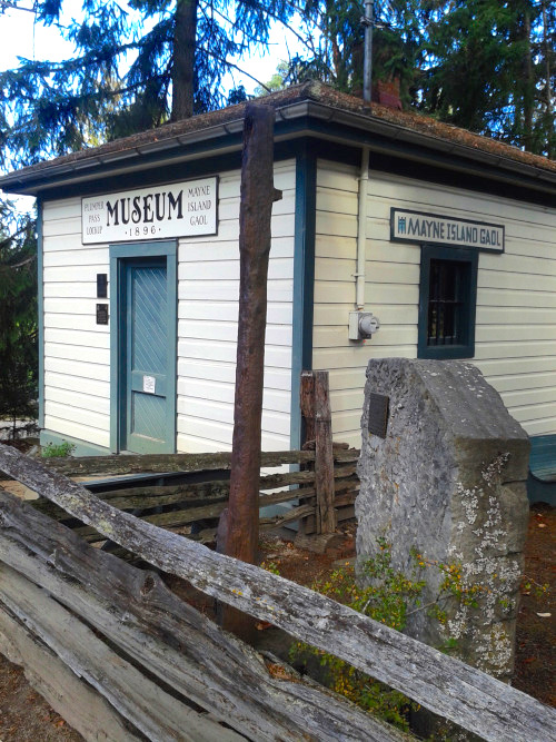
Mayne Island Museum and Gaol. Source: http://gulfislandsnprcoop.tumblr.com/
The only thing better than small town museums are small town thrift shops, but it’s close. I stuck my nose into the Mayne Island — a small island in the Salish Sea — Museum a day or two ago, which is housed in the former gaol (that’s “jail” for my diverse readers). These museums can be fun, but you do have to put on your “this place is historically situated” eyeglasses. As in, there is usually an enormous preponderance of Settler material, and often there is a fairly reductionist, colonialist or otherwisely unfortunate depiction of First Nations. The Mayne museum doesn’t escape this altogether. The First Nations display is probably 5% of the total, both in material display, and in the timeline presented (I didn’t take a picture but it is typed out pretty much verbatim here, compare to my pie chart timeline). Anyway, I don’t want to focus on any negative vibes from the museum, they share the general issues of almost every community museum I’ve been to, but neither do I want to ignore them completely. To their credit they have a good section the Japanese Internment Camps and the fate of Japanese-Canadian islanders during World War II. Anyway, I took a few lousy pictures with my phone and I’ll share these below and in a subsequent post (since really who wants to read 2,000 words of pontification in one sitting?) We’re going to start with my favourite artifact type.

Frank Sylvester Burial Cairns Manuscript, Page One. Source: UVic Special Collections: http://goo.gl/mSxBGe
There’s an interesting manuscript digitized in the University of Victoria’s special collections library, entitled “Prehistoric Cairns of Vancouver Island.” The accession notes read:
“Handwritten manuscript, on ruled paper with red-lined margin. Pages hand-numbered 1-20. Signed and dated: Frank Sylvester, Victoria, B.C., June 10, 1901. Appears to be notes for a talk that Frank Sylvester gave, concerning burial cairns on Vancouver Island, his method of excavation of the cairns, and his theories as to the meaning of the cairns and the ancestry of the people buried there.”
It’s a curious document, a mixture of interesting observation, shameless plunder and racial theorizing. It’s also one of the more complete descriptions I’ve seen of the burial cairn excavation activities of the Victoria Natural History Society. I don’t recall seeing it cited in the literature, so it’s possible others haven’t come across it either. In the interests of broad circulation and easy reading, I’ve transcribed it (PDF), and I also put a version on google docs if anyone cares to improve that transcription.
Posted in anthropology, Archaeology, archives, First Nations, history, Northwest Coast, Vancouver Island
Tagged burials, cairns, cemeteries, Esquimalt, Frank Sylvester, Songhees, uvic

Grave near Victoria on the harbour, 1859, by William Tyrwhitt-Drake. Source: British Museum. Click for their record and verso.
So, not long ago we had an excellent discussion here centered around Edward Richardson’s 1864 painting of a Coast Salish grave house or mausoleum. I’ve recently come across another set of images of these places which are so important to First Nations. These images were painted by well-known early Victoria resident (and former mayor and Supreme Court of BC Justice) Montague Tyrwhitt-Drake. They’re pretty interesting paintings from the early colonial period on southern Vancouver Island which I don’t recall seeing before.
The painting above clearly shows a small mausoleum, weighted with rocks on top, in front of which are two carved figures. The one on the right includes fishers or river otters, both of which have important spiritual significance in this area. Each of these images has notes on the back, which are also reproduced at the British Museum site (click the image to go to the accession record). For this image, the notes aren’t transcribed, though maybe someone with better olde handwritinge fkills would care to have a go As near as I can make out, the back reads:
This is another eccentric specimen of Indian taste for sculpture, it is equal to the finest specimens of _________ — see the elegant attitude of that man scratching his ?cheek bone, but a _____ ________ _______ would have mastered __________ a flight of ___________ imagination. The other is holding two dogs [sic] of a breed which I am afraid is lost to the present generation. This ______ are carved in wood and _____ ________ near a large grave of the family vault above ground ___________ .
It”s true, both sculptures are lively and naturalistic. In both cases, and the one below, there is apparently a rendering of face paint. I’m sure those readers more knowledgeable than I will see a lot of interesting detail in these pictures. Note the open prairie environment – anthropogenic Garry Oak meadow, no doubt.
Posted in Archaeology, archives, First Nations, Northwest Coast, Vancouver Island
Tagged Esquimalt, graves, mausoleum, mortuary, painting, sculpture, Songhees, Victoria, Victoria BC, William Tyrwhitt-Drake

Screen shot from video of men building a fish weir near Atka, ca. 1946. Click to see video. Source: http://vilda.alaska.edu/cdm/singleitem/collection/cdmg11/id/37038/rec/36
So, still rustling around the weird world of weirs. The online Alaskan archives have quite a few interesting examples – and, kind of remarkably, a video showing the construction of a weir near Atka, which is on the Aleutian Islands. The trap in the video is pretty similar to a couple of other Aleutian ones in the collection, which I’ll talk about below. It’s really cool to not only see a more-or-less traditional trap being built (look at the rocks being casually dropped down by the wooden fence!) but the photos also show weirs actually in use. There’s probably a lot to learn from these pictures – as any introductory textbook in archaeology will tell you, the more we know about the behavioural context of a given site type, the more we can reliably infer the cultural context when presented only with the archaeological remains.
Posted in alaska, Archaeology, archives, First Nations, Northwest Interior, Northwest Coast, Technology
Tagged aboriginal fisheries, alaska, fish, fish traps, fish weirs, salmon, weirs, Yukon
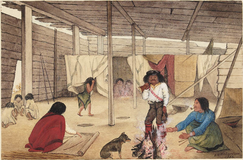
Interior of a Salish Longhouse, 1864. Watercolour by Edward Mallott Richardson. Locale uknown. Source: Canadian Archives. Click to enlarge.
Following on from the post about the Salish mausoleum, here is a companion painting by Edward Mallott Richardson from the same year, depicting the interior of a house. It’s a curious painting, seemingly devoid of close detail. Where are all the drying fish?! But at the same time it shows some features of interest which may be worth discussing. Note the fellow with the gun has a powderhorn, for example, and the basket behind him looks like one of those rectangular coiled ones, only with a tumpline, as shown by the woman entering on the left. On the far right is a semi-conical object that might be a hat, sitting on a platform within a small compartment.
Posted in archives, First Nations, history, Northwest Coast, Vancouver Island
Tagged art, Coast Salish, First Nations, household archaeology, longhouses, Salish, Straits Salish, Victoria BC

| Has There Ever Been… on Destruction of Kwalate Vi… | |
| George La Plante on Arborglyph | |
| Kira Sokolovskaia on dSpace: Lundy on Rock Art | |
| Kira Sokolovskaia on dSpace: Lundy on Rock Art | |
| George La Plante on Arborglyph | |
| At the Boundary Betw… on Samuel Hancock witnesses small… | |
| At the Boundary Betw… on Samuel Hancock witnesses small… | |
| Cooler Aloft –… on Oregon Earthquakes and Ts… | |
| Tom Dailey on Salish Villages of Puget … | |
| Stuart Jenner on Samuel Hancock witnesses small… | |
| Melissa Taliana on Alaskan Fish Weir Photos | |
| Melissa Taliana on Alaskan Fish Weir Photos | |
| Alex on Tree Burials at Tsaxis | |
| The Forgotten Fluffy… on Coast Salish “Woolly Dog… | |
| Sue Thomas on La Brea Woman: Image Cont… |
