Tag Archives: Kilgii Gwaay

ASBC Victoria Talk: Tuesday September 16, Jenny Cohen on Paleoethnobotany of Kilgii Gwaay

2002 excavations at Kilgii Gwaay Site.

2002 excavations at Kilgii Gwaay Site.

Paleoethnobotany of Kilgii Gwaay: a 10,700 year old Ancestral Haida Archaeological Wet Site

Jenny Cohen

Tuesday, September 16, 2014, 7:30 pm

Cornett Building B129

(North End of Cornett building)

University of Victoria (map)

The Victoria Chapter of the Archaeological Society of BC (ASBC) has a long-running monthly Fall-Spring speaker series which is starting again next week.  The speaker is UVic Anthropology graduate student Jenny Cohen, speaking on results from her paleobotanical analysis of the 10,700 year old intertidal wet site, Kilgii Gwaay, in southern Haida Gwaii.  It’s a fascinating site which gives real insight into the way of life of Ancestral Haida at the Pleistocene-Holocene transition and I’m sure Jenny’s thesis, nearing completion, will be of wide interest.

If you don’t have enough Kilgii Gwaay in your life then I recommend you jump over to the Burnt Embers blog, where there are some excellent photos from the tricky intertidal excavations at that site a few years ago: Setting Up;  Keeping Water Out; Putting Water InWater Screening; and Kilgii Gwaay Finds.

Abstract: Continue reading

Public talks in Vancouver and Victoria

Unusual fish hook fashioned from a canine tooth.  Burnaby Narrows, Haida Gwaii, 2012.  Photo by Jenny Cohen.

Unusual fish hook fashioned from a canine tooth. Ca. 3000 years old, Burnaby Narrows, Haida Gwaii, 2012. Photo by Jenny Cohen.

Quick note to say there are two forthcoming public talks that might be of interest to residents of Vancouver or Victoria.  The Vancouver one is by Dr. Ken Ames, Professor Emeritus at Portland State University, speaking at UBC on Thursday October 18th at 11.30.  The Victoria one is by yours truly, speaking to the Archaeological Society of BC on Tuesday October 16th at 7.30.  Details are below. Continue reading

Annotation: Collison Bay

Annotation of the Collison Bay night-time, low tide excavations.

The Collison Bay site in Haida Gwaii  posed some unusual challenges, some natural and others of our own making.  The site is found in the intertidal zone and dates, like the Kilgii Gwaay site about 10 km away, to a brief window about 10,700 calendar years ago.  I posted the above picture before, but without annotation.  That previous post describes something of the site formation processes, which mean a site which was terrestrial when occupied is now in the intertidal zone, and excavation must take place between the tides.

Looking at the above, you can see we didn’t plan for the tides very well!  other projects required us to be elsewhere and when it was Collison Bay’s turn, the low tides were in the middle of the night.  This meant we had to get up at midnight to work until about 6.00 in the morning the first night to catch the falling tide, then we got up about 12.45, then about 1.30, and so on: tracking the procession of the low tides.  So, to the inherent complications of working in the intertidal zone we did it in the dark, running electric lights from a generator.  This actually worked really well and data recovery was excellent – we dug there on another occasion in the daytime (see below) and there was no real difference in quality of work.  Also part way through this project we were working until mid-morning and could see pretty well!

The site includes numerous water-worn stone tools on the surface and in the upper beach deposits, but in the lower beach deposits the tools are pristine and show no signs of water-rolling.  In many cases they lie flat, also suggesting a lack of disturbance, and they are encased in a thin, brown layer of jelly-like material which is the organic remains of a degraded soil.  Unlike at Kilgii Gwaay, there is no survival of bone or wood.  Nonetheless, the stone tools are very similar to that site, and speak to a terminal Pleistocene technological approach using discoidal and uni-directional cores to create large blade-like flakes.  Too much information for some readers I bet – but the take home message is this way of making stone tools might be peculiar to the  Pacific Rim and not the continental interior and therefore might, perhaps, maybe, one day, turn out to have significance for the coastal route of the First Peopling of the Americas.

Pristine, sharp blade-like flakes used as stone tools from 10,700 year old deposits in the beach at Collison Bay. Flake on right is about 6 cm long. Photo: D. Fedje

Establishing an excavation unit as soon as feasible on a falling tide to maximize digging window.

Videos of Gwaii Haanas Archaeology

Daryl braves the barrage of bras to set the Vancouver Aquarium straight on the value of dead fish over living fish. Click to play part 1.

Rockwash superstars Nicole and Daryl show off their cool wares in a couple of videos I just found online – I vaguely remember them going off to give this talk at the Vancouver Aquarium.  It’s in two parts: 1 and 2.  Nicole looks fabulous and Daryl has trimmed his beard!  Win-Win.  The projects they describe sure were a lot of fun to take part in.   There are a few other talks up including Lyle Dick and Norm Sloan on Sea Otters on the Gwaii Haanas Youtube Channel.

A sandhill crane is a tough act fo follow but Nicole hammers home the righteous message of dead fish. Click to play part 2.

Annotation: Kilgii Gwaay excavations.

Excavation at Kilgii Gwaay, southern Haida Gwaii.

I’ve found that individual powerpoint slides can be saved as JPG images, complete with their annotations.  Since I have a lot of these I may share some.  The above shows excavation in the shell-rich component of the intertidal site at Kilgii Gwaay.  The combination of shellfish remains and saturation in slightly alkaline sea water has produced remarkable preservation for a site which is firmly dated via about 20 carbon samples to 9450 14C BP, or around 10,700 calendar years ago.  In this picture you can see some of the evidence: bone tools, stone tools, and the remains of shellfish, fish and mammals which, together with birds, formed the basis of the diet at this summertime camp.

Continue reading

Fieldwork Picture of the Day 7

Excavations at Collison Bay, 2006

Excavations at Collison Bay, 2006

This is another intertidal dig – the Collison Bay site, which shares a lot of similarities with Kilgii Gwaay.  Both sites date to about 9450 C14 years ago and contain buried deposits in primary context below the modern beach.  While Kilgii Gwaay contains a rich organic assemblage, Collison Bay does not, though there is evidence for a brown palaeosol at varyiong depths.  In and around that palaeosol are numerous pristine lithics: stones tools and flakes that are sharp and clearly have not een rolled on a beach.  One of the striking things about these two sites is they show how a major event like a marine transgression can nonetheless leave intact cultural deposits.  We suspect that much of this has to do with the local topography.  Ideally, a bedrock rock rim allows for a small lagoon to form, creating an interlude of very low wave energy between when sea level rises over the site and when the full weight of waves can start to act on the surrounding shore.  By the time the waves are able to penetrate, the archaeological materials are already several metres below low tide which affords quite a lot of protection.

As with Kilgii Gwaay, working in the intertidal zone poses certain challenges, such as having only a six hour window to work.  In the case of Collison Bay, we compounded the issue by timing the project for when the best tides were in the middle of the night, which meant getting up at midnight and working to dawn in some cases (though we did have some good daytime digging as well).  In this picture you can see we are using electric lights run off a generator while Cynthia does the hard work down on the beach; this is probably around 2.00 in the morning.

Fieldwork Picture of the Day 2

Daryl watching the tide flow at Kilgii Gwaay.

Daryl watching the tide flow at Kilgii Gwaay.

Another fieldwork picture form the archives. This shows Daryl watching the tide come into our units at Kilgii Gwaay (map) – this is Operation 8a and 8b, if I recall, from 2001.  At first we tried to completely dig out a unit during a single tide window but this was quite rushed, and limiting.  So we tried lining the units with bubblewrap and then just before the tide reached them we would pump them full of water (hose into a bucket in the bottom of the unit) to provide outwards pressure on the sidewalls and to prevent erosion of the unit edge.  This actually worked really well: for the most part the units survived the tidal change and could be pumped out with no trouble.

Fieldwork Picture of the Day

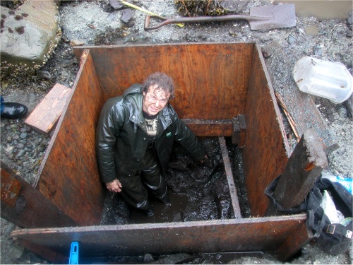
Duncan with his feet in a 12,000 year old bog

Duncan with his feet in a 12,000 year old bog

While doing the Anthro 449 site, I’m finding a lot of pictures I haven’t seen lately, so I might as well post some of them here.  This one shows Duncan digging at Kilgii Gwaay (map) in 2002.  This was an unusual project, working in the intertidal zone between tidal windows — so about 6 hours per day of frenzied activity (read: poor napping) until the unit flooded again.  In this instance, the unit was 4 foot by 4 foot to accomodate the dimensions of plywood shoring.  There wasn’t a lot down in this unit, at least not archaeologically, but we do have a huge sample of woody bits from the organic deposits at the bottom.  In essence, the unit was placed on the edge of an ancient pond that formed post-glacially and  then lived a quiet life in the anonymous southern forests of Haida Gwaii – only to be rudely interrupted around 9450 14C years ago by rising sea levels, which made it attractive for a brief window of human occupation.  So – from a small pond in the forest, to a busy camp site, to a beach, all in a span of about 50 years.  And now, with falling sea levels, back to a beach.  The archaeological site is eroding somewhat, but nonetheless there are patches of intact shell midden and as it shows here, a large amount of terrestrial freshwater-saturated pond splooges under this beach.