Tag Archives: Esquimalt

“Prehistoric Cairns of Vancouver Island”: notes for a lecture given in 1901

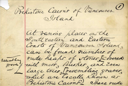
Frank Sylvester Burial Cairns Manuscript, Page One. Source: UVic Special Collections: http://goo.gl/mSxBGe

Frank Sylvester Burial Cairns Manuscript, Page One. Source: UVic Special Collections: http://goo.gl/mSxBGe

There’s an interesting manuscript digitized in the University of Victoria’s special collections library, entitled “Prehistoric Cairns of Vancouver Island.”  The accession notes read:

“Handwritten manuscript, on ruled paper with red-lined margin. Pages hand-numbered 1-20. Signed and dated: Frank Sylvester, Victoria, B.C., June 10, 1901. Appears to be notes for a talk that Frank Sylvester gave, concerning burial cairns on Vancouver Island, his method of excavation of the cairns, and his theories as to the meaning of the cairns and the ancestry of the people buried there.”

It’s a curious document, a mixture of interesting observation, shameless plunder and racial theorizing.  It’s also one of the more complete descriptions I’ve seen of the burial cairn excavation activities of the Victoria Natural History Society.  I don’t recall seeing it cited in the literature, so it’s possible others haven’t come across it either.  In the interests of broad circulation and easy reading,  I’ve transcribed it (PDF), and I also put a version on google docs if anyone cares to improve that transcription.

Continue reading

The Giant of Happy Valley

The giant of Happy Valley Esquivalt(?) [sic].  Sent to Professor Flower at Nat Hist Mus and returned to the owner Left McCallum. Source: British Museum.

“The giant of Happy Valley Esquivalt(?) [sic]. Sent to Professor Flower at Nat Hist Mus and returned to the owner Left McCallum.” Source: British Museum.

When I was looking for more information about the Coast Salish grave houses I pictured a few days ago, I ran into these images from the British Museum.  They show the torso and head of a large human figure, carved out of wood.  The height of the sculpture is 4 foot 9 inches, meaning the whole sculpture, assuming it once had legs, would have stood well over seven feet tall.  So, a giant indeed.  There is very little information about the sculpture, other than it comes from happy Valley, “Esquivalt” – clearly meaning Esquimalt – a neighbouring municipality to the west of Victoria.  The next municipality to the west is Colwood, and indeed it has a prominent “Happy Valley Road” running through it into Metchosin.  While at the first glance the sculpture doesn’t appear to be a typical NW Coast sculpture, I think there’s reason to at least consider that possibility.

[edit: be sure to see the comment from Pete at the bottom]

Continue reading

Coast Salish Mausolea, Victoria, 1859

 Grave near Victoria on the harbour, 1859, by William Tyrwhitt-Drake.  Source: British Museum. Click for their record and verso.

Grave near Victoria on the harbour, 1859, by William Tyrwhitt-Drake. Source: British Museum. Click for their record and verso.

So, not long ago we had an excellent discussion here centered around Edward Richardson’s 1864 painting of a Coast Salish grave house or mausoleum.  I’ve recently come across another set of images of these places which are so important to First Nations. These images were painted by well-known early Victoria resident (and former mayor and Supreme Court of BC Justice)  Montague Tyrwhitt-Drake.  They’re pretty interesting paintings  from the early colonial period on southern Vancouver Island which I don’t recall seeing before.

The painting above clearly shows a small mausoleum, weighted with rocks on top, in front of which are two carved figures. The one on the right includes fishers or river otters, both of which have important spiritual significance in this area.  Each of these images has notes on the back, which are also reproduced at the British Museum site (click the image to go to the accession record). For this image, the notes aren’t transcribed, though maybe someone with better olde handwritinge fkills would care to have a go  As near as I can make out, the back reads:

This is another eccentric specimen of Indian taste for sculpture, it is equal to the finest specimens of _________  — see the elegant attitude of that man scratching his ?cheek bone, but a _____ ________ _______ would have mastered __________ a flight of ___________ imagination. The other is holding two dogs [sic] of a breed which I am afraid is lost to the present generation. This ______ are carved in wood and _____ ________ near a large grave of the family vault above ground ___________ .

It”s true, both sculptures are lively and naturalistic. In both cases, and the one below, there is apparently a rendering of face paint.  I’m sure those readers more knowledgeable than I will see a lot of interesting detail in these pictures.  Note the open prairie environment – anthropogenic Garry Oak meadow, no doubt.

Continue reading

A Coast Salish Mausoleum, 1864

A Salish Grave, 1864. Watercolour by Edward M. Richardson. No specific locale given. Source: CollectionsCanada.gc.ca

A Salish Grave, 1864. Watercolour by Edward M. Richardson. No specific locale given. Source: CollectionsCanada.gc.ca  Click to enlarge slightly.

“Grave House” is one of those archaeological terms which render slightly creepy a feature that is more or less an everyday experience: the mausoleum, a house for the dead, filled with coffins.

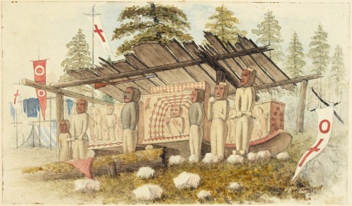
This is a fascinating image I hadn’t come across before: a very early image of a Coast Salish mausoleum.  It highlights the artistry and vividness of these features better than the few sketches or early photographs do. The accompanying text at the Canadian Archives is:

Subject depicts grave boxes in a grave house with guardian figures. The grave house is covered with a roof of wooden planks but has no walls. At the front of the house stands six guardian figures. There are flags to the left and right of the house. On the left hand side of the house a tent is set up and clothes are hanging. A shotgun hangs from the front beam of the house. Item was up for auction in the September 28, 1970 Christie’s sale in Calgary. Lot 31.

The image isn’t very high-resolution but there are still some things to talk about – and there is another Richardson painting I’ll link to in a day or two. (edit: here) Continue reading

Victoria ASBC Public Talk, Tuesday May 17: Locarno Houses?!

UVIC students visiting "Aquattro Site" near Esquimalt Lagoon, 2008.

The next scheduled public talk of the Archaeological Society of BC, Victoria Chapter, will be held next Tuesday evening at 7.30 at the Pacific Forestry Centre, 506 West Burnside Road (map).  The talk is free and open to any member of the public.

The talk is entitled Preliminary Investigation Results from DcRu-1151: A Locarno-Age Living and Processing Site at Esquimalt Lagoon, and will be given by local archaeologists Kristi Bowie and Kira Kristensen.

I had the pleasure of visiting this site while it was being excavated a few years ago.  All signs were that the site included the remains of a house dating to between 2500 and 3500 years ago, the “Locarno Beach” period, though at that time the feature was not directly dated.  Very little is known of domestic structures from this time and so the finds could be quite exciting. I’m looking forward to hearing more about this site, though it is doubtful I will be able to attend this talk due to the ongoing circumstances which also keep this blog running slowly.  I am pasting in the abstract and speaker biographies below, or else click here for the PDF.

Continue reading

Victoria’s history through cartoons

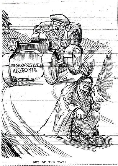
"Progressive Victoria" about to run over the Songhees. Was there ever a Songhees man with feathers in his hair, fringed buckskin, and a peace pipe? Source: Vincent's Victoria.

I mentioned it in a comment the other day so you may have seen it already, but there are a couple of great posts at the blog “Vincent’s Victoria“.  The first post is the already-mentioned review of John Lutz’s talk “Getting the Indians Out of Town: Race and Space in Victoria’s History” – Victoria, British Columbia, that is, better known as World Headquarters to this blog.   In Vincent’s post we find out about the slow process by which First Nations had their presence in the city core steadily reduced, mainly by moving the reserves, but through other means too.  The post then discusses the “Signs of Lekwungen” project which I posted on before. it’s really a shame I didn’t hear about John’s talk until after he had given it – there are other talks in the series but his would have been the most interesting to regular readers here.

The second post is extremely interesting, as it uses editorial cartoons from the Victoria Daily Times newspaper to tell the story of the movement of the Songhees reserve in 1910.

Continue reading

Signs of Lekwungen

Signs of Lekwungen "Walk in Two Worlds", near corner of Fort and Wharf Street in Victoria. Source: Flickr.com user ngawangchodron

The city of Victoria in collaboration with the Songhees and Esquimalt First Nations has fairly recently created a series of outdoor art installations which mark culturally-significant places.   As the City’s online brochure explains,

Established in 2008, the Signs of Lekwungen (pronounced Le-KWUNG-en) is an interpretive walkway along the Inner Harbour and surrounding areas that honours the art, history and culture of the Coast Salish people who have resided in the Victoria area for hundreds of years.

The Songhees and Esquimalt Nations are part of the Coast Salish family and are descendants of the Lekwungen family groups. Lekwungen is the original language of this land.

The Signs of Lekwungen consist of seven unique site markers – bronze castings of original cedar carvings, conceptualized and carved by Coast Salish artist, Butch Dick. The markers depict spindle whorls that were traditionally used by Coast Salish women to spin wool. The spindle whorl was considered the foundation of a Coast Salish family.

Continue reading

VicNews: Rebirth through Reburial

Burial cairn on Race Rocks. Source: RaceRocks.com

While I was away over the summer the local free paper, the Victoria News, did a (to my mind)   high quality series on reburial and respect in Songhees and Esquimalt communities (cache). The three articles by Lisa Weighton include comments from numerous aboriginal spiritual and political leaders, and sensitively describes how Straits Salish faith asserts that the dead are always with the living.  The dead do not conveniently depart to some other place, but continue in a world alongside and intersecting the world of the living.

Hence ancestral remains are not something belonging to a past which can be “gotten over” but are very much part of the present world.  Laying a person to rest, or back to rest after disturbance, requires food, clothing and prayer.  I don’t pretend to understand the concept well, but I have been to some such ceremonies and the power of the moment is impossible to deny.  In my limited experience the article fairly represents the spiritual and emotional needs that must be met under the sad circumstance of disturbing the dead.  It is incumbent on archaeologists and all citizens to not only work to minimize disturbance of the dead but to respect traditional practices.  It has been impressed on me that such practices are meant to protect us, the living, First Nations or not, as well as to give comfort and respect to the dead.  This should now be considered absolutely part of mainstream archaeology.

Continue reading

Historic Maps and Dioramas of Victoria and Environs

Detail of Capt. Vancouver's 1792 chart showing the "supposed strait of Juan de Fuca". Source: viHistory

vihistory is a web site designed to aid in historical research of Vancouver Island, at which it succeeds admirably.  You should poke around and have fun with their census data and the other worthy, if dreary, pursuits it affords the serious scholar.

One feature which is not immediately clear on first glance, perhaps deliberately as has entertainment potential, is a large selection of very high-resolution maps and images which you can download from this page. The file sizes are large, of course, but increasingly that is less of an obstacle in the past.  The maps are mostly of historic Victoria, but there are some regional maps such as telegraph and lighthouse maps of British Columbia, and a couple of maps of Nanaimo.  As usual, I have surfed through the maps so you don’t have to – and some of them are remarkably fun, and informative.

Continue reading

Photos of Victoria and Esquimalt, 1859

Victoria 1859. Source: LOC

In 1846, the Oregon Treaty established the boundary between British and American territory west of the Rockies (and unintentionally established the benchmark date for whether archaeological sites are automatically protected under the Heritage Conservation Act, but that’s another story).  Vancouver Island was to remain in British hands in its entirety, but otherwise the 49th parallel was to be the boundary on land.  The ocean boundary through the Salish Sea was resolved later, after the armed standoff on San Juan Island known as the “Pig War“.   An International Boundary Commission was struck, with the mandate of surveying the 49th parallel and one of its base camp headquarters in 1858 and 1859 was Esquimalt.  At this time, a series of photographs of the young Fort Victoria and surrounding buildings were taken, some of the earliest photographs from British Columbia I know of – including some remarkable pictures of First Nations people.

Continue reading