Tag Archives: underwater archaeology

ASBC Victoria November 21st Public Talk: Underwater Survey for Late Pleistocene Archaeological Sites, Haida Gwaii

Autonomous Underwater Vehicle on surface of Juan Perez Sound, Haida Gwaii, with Parks Canada support vessel behind.

Autonomous Underwater Vehicle on surface of Juan Perez Sound, Haida Gwaii, with Parks Canada support vessel behind.

With sea levels rising by at least 120m globally at the end of the last ice age, conventional archaeological wisdom has been that sites on ancient coastlines are now deeply drowned. As is so often the case, conventional wisdom is over-simplified.  The B.C. coast is a good example, since the effect of ice weighting in some places counterbalanced the lower sea levels, meaning significant chunks of the coastal plain and paleo-coastlines were never-drowned.  Nonetheless, the underwater environment off the west coast doubtless contains thousands of early-period archaeological sites. Looking on land is more convenient, easier, cheaper, and allows one to breathe air – all good things. But looking underwater has some attractions too: methodological challenges, modelling issues, thinking about human life on a shrinking landmass, and a ridiculous amount of media coverage. The last is particularly important to University Administrators. Anyway, this month’s ASBC Victoria talk (poster, PDF) is on a project from a couple of years back which focused on attempting to find a particular kind of archaeological site on the sea floor: drowned fish weirs, especially rock wall ones, starting from the premise that such sites, which are often substantial in size,  should be confined to stream channels and might be directly visible to sidescan sonar.  For more information on the talk, click below.

Continue reading

ASBC Victoria Meeting, April 17/2012: Underwater Archaeology in BC

Parks Canada Archaeologist near Huxley Island

So, it’s been a while without a post here so apologies to compulsive page-refreshers and lonely groupies.  I see lots of interesting comments – I’ll try to get caught up soon. For now, here is the announcement about the Victoria ASBC meeting coming up this Tuesday.  It’s great to see that there is going to be some dialogue between the ASBC and the UASBC – two solitudes far too much of the time.

Jacques Marc

Underwater Archaeological Society of BC

Exploring the Underwater Heritage of British Columbia

TUESDAY April 17, 2012, 7:30 pm
Pacific Forestry Centre,
506 West Burnside Road. (map)

Free and Open to the Public

Continue reading

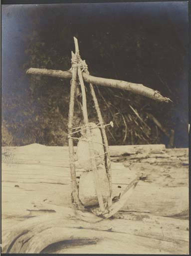
Anchor Stones

Duwamish composite stone anchor. Source: UW.

Edit October 2018: Hoko Pictures are now here.

I was talking the other day about how under-represented organic technology is in archaeology generally, and especially on the Northwest Coast, where the old adage is that 95% of the technology was made out of plants (trees, wood, bark, roots, grasses, seaweeds).  A classic example of this phenomenon are anchor stones and sinker stones.  While some of these stones had grooves or perforated holes (and are thereby very visible and durable in the archaeological record), many may have been made by the more simple, subtle and expedient method of simply wrapping line or basketry around an unmodified rock.  When the organic component rots away, as it will most of the time, then the archaeologist has, well, an unmodified rock.

Anyway, it was a lucky stroke for my current interest that I came across the above photo from the University of Washington Digital Archives.

Continue reading

Imaging of Yukon Shipwrecks

3-D Sonar Scan of A.J. Goddard historic sternwheeler from Yukon. Source: Montreal Gazette.

A year or two ago, the well-preserved wreck of the Klondike-era paddlewheeler A.J. Goddard was found in Lake Lebarge on the Yukon River.  The find (which is now protected) got a lot of attention because of the ghostly images (click on the very high resolution pop-up ones here) as much as the historical significance.  The wreck was recently in the news again because divers had found some vinyl phonograph records which had the potential to be played. Listening to the music of the dead crewmen of a ship evocative of the Cremation of Sam McGee would create close, perhaps emotional, connection with these poor unfortunates.

Being made of stern stuff (heh) what I am more interested in is the intriguing  sonar image (above) that accompanied the mainstream press coverage.  The phonograph is cool, but archaeologically the more significant development are the new technologies being used on wrecks in general and some Yukon wrecks in particular.

I found more images and a very short article at Wired magazine and they are worth a look, as is much of the background info from the Institute of Nautical Archaeology (INA), which includes a photo galleryEdit: you can view a nice video of BluView and OceanGate’s sonar model of the wreck here.

Continue reading

Dixon’s Underwater Entrance

Waters around OYK Cave. Source: Polarfield.com

E. James (Jim) Dixon, now at the University of New Mexico,  is pretty well known on the Northwest Coast for his pioneering work at the 10 to 12,000 year old 49-PET-408 (“On Your Knees Cave”) in the Alaskan Panhandle, and more recently for his exciting work on Alaskan Ice Patches. I see now that he apparently received some funding to go underwater during the summer of 2010 in the waters around PET-408, not far north from the aptly named Dixon Entrance, in Southeast Alaska (map).  This work could have implications for the coastal route of First Peopling of the Americas.

Continue reading

The Wreck of the Kad’yak

Cannon from the Kadyak on the seafloor near Kodiak Island. Source: Archaeology Magazine.

Off Alaska’s Kodiak Island lie the remains of the Russian-American Company ship Kad’yak, which sank in 1860.  The wreck of this Barque was rediscovered in 2003, as this first-hand account documents.  (It is full of the usual intrigue between divers and dirters and is rich with interesting links about the discovery).  Almost immediately, an underwater archaeological research project was formed, participants included people from the Kodiak Maritime Museum, the Baranov Museum, the Alutiiq Museum, the State of Alaska Department of Natural Resources, NOAA National Marine Fisheries Service in Kodiak, and East Carolina University.  This was the first underwater archaeology project in Alaska, and it is ably documented by the Alaska Office of History and Archaeology.

Continue reading

State Underwater Archaeology Overviews

Part of a sunken fleet of recreational dories, Emerald Bay, California.

The US National Parks Service has a useful page summarizing policies and laws regarding “submerged resources” – which includes underwater archaeological sites.  The sections most of interest to the six readers of this blog are probably the pages on Washington State, Alaska, Oregon and California — though the fact that Idaho has a page is, at least, surprising until you remember the importance of paddle-wheelers in the earlier interior historical period all over the west.

Another Emerald Bay dory. Source: http://www.parks.ca.gov/default.asp?page_id=22707

Shipwrecks of Vancouver Island

The three-masted ship Carelmapu with decks awash, dragging her anchors into Schooner Cove, near Tofino, in 1915

The ‘Virtual Museum of Canada”  has been responsible for some nice online exhibits, although a lot of these are now fairly dated.  One with what we could call a “retro web design”, but some good content, is the Shipwrecks of Vancouver Island site, apparently put together mainly on the watch of the Maritime Museum of BC with help from the Underwater Archaeological Society of BC.  There are some nice videos of underwater archaeology, and other informative materials.

Site navigation, though, is much easier if you just go to the site map here — the absurdly finicky navigation does weird things like, say, means using the back button always takes you to a splash introduction screen — is a crime against the web.  Especially since museum people are involved: why such disdain for solid future-proof web design values?  This page, for example, has a nifty slider to scroll through an interactive map: but if you don’t pay attention (e.g., if you use your back button) you will always end up on a “loading XML – introduction to the database” overlay screen page which gets tired after about the third time.  The VMC should consider a legacy fund to make sure that the sites which they poured money into for a while can all be kept up to date for both content and also compliance or at least ease of use.  It would not surprise me in the slightest if the VMC had spent over $100,000 on this site — the one site of their I know something about they spent $140,000 and it is no flashier than this thing.  Almost all that money went into design and mounting of content, very little went to the content creators themselves.  If that  applied here, I think we have a right to expect more – is this site design worth $100,000?  It seems to me that, even in 2004, a competent web designer working alone, with content given by others, could have put this together in about a month.

Canadian Navy diver goes overboard in 1959 to examine the 1853 wreck of the Lord Western, near Flores Island.

Videos of Gwaii Haanas Archaeology

Daryl braves the barrage of bras to set the Vancouver Aquarium straight on the value of dead fish over living fish. Click to play part 1.

Rockwash superstars Nicole and Daryl show off their cool wares in a couple of videos I just found online – I vaguely remember them going off to give this talk at the Vancouver Aquarium.  It’s in two parts: 1 and 2.  Nicole looks fabulous and Daryl has trimmed his beard!  Win-Win.  The projects they describe sure were a lot of fun to take part in.   There are a few other talks up including Lyle Dick and Norm Sloan on Sea Otters on the Gwaii Haanas Youtube Channel.

A sandhill crane is a tough act fo follow but Nicole hammers home the righteous message of dead fish. Click to play part 2.

Raven-Walking & Geological Transformation

Haida History starts at least 14,500 years ago. (Image credit: Daryl Fedje).

Three things we know about Haida Gwaii:

1.  About 14,500 calendar years ago it was a temperate tundra environment, with no trees.  The first trees, pine, appear about 14,000 years ago and there is progressive forest infilling thereafter, with the modern species mixture in place by about 3,000 years ago.

2. It has an impoverished suite of large land mammals – historically, these were limited to black bear, caribou, marten, ermine, a vole and a shrew.  We know that 13,000 years ago there were also deer and brown bear on the islands, and quite likely other species as well.

3.  It used to be much larger than in the present.  With lower sea levels at the end of the last ice age, Hecate Strait was largely dry land, exposing a large, unglaciated, coastal plain that became rapidly flooded.

It seems to me that we can add a fourth thing we know:

Continue reading