Tag Archives: stone tools

Glaciers brought mountain to man (not really)

Dionisio Point. Main vlillage sites in central upper portion of image. Credit: Colin grier via NPR.

Dionisio Point, north end of Galiano Island. Main vlillage sites (DgRv 6) in central upper portion of image. Credit: Colin grier via NPR.

A couple of months ago you may have heard of an exciting new study on the sources of rock for making stone tools in the Salish Sea.  “Glaciers brought mountain to man“, the headlines said, affirming that archaeologists working on Galiano Island had found nodules of raw material, not yet worked into tools, from the Mt. Garibaldi area of the lower mainland.  If, like me, you have a rudimentary knowledge of Salish Sea archaeology, you probably leapt to the conclusion that the raw material would be from the Garibaldi obsidian source.  So, cool: the mountain moves to Mohammed after all.  But, despite my being fairly disapproving of both sobriety and thinking in general, sober second thought did have me wondering: is it even possible that glaciers carried raw material from Garibaldi to Gabriola?  And from the relatively small and isolated high-altitude obsidian sources to a prominent village site?  ” It was brought there by glaciers, conveniently, 12,000 years ago”, the article asserts – thousands of years past the local ice maximum.  It didn’t easily compute. Luckily I was emailing with one of the paper’s authors, Dr. Colin Grier from Washington State University, and he set me straight on how the new article came to have something of a misleading takeaway point, while shedding some light on his recent interactions with the press.

Continue reading

ASBC Victoria: Public Talk Tuesday Sept 20, Barkley Sound Archaeology

Kelsey, Rodney and Jinky in the older deposits at Hiikwis.

The local (Victoria) branch of the Archaeological Society of B.C. is firing up it’s winter lecture series.  The first talk is on Tuesday, and features UVic’s own Kelsey MacLean, speaking on the enigmatic stone tool assemblage from Hiikwis, in Barkley Sound.  Details below; it is free and open to the public.

Kelsey MacLean

M.A. Candidate, University of Victoria

Chipped Stone in Barkley Sound.

Abstract: In 2008, Hiikwis became the first archaeological site in Barkley Sound with a significant sample of chipped stone materials. This material provides new insights into the culture history of Barkley Sound and the Nuu-chah-nulth peoples. It is well known that settlement patterns changed drastically in Barkley Sound from approximately 1500 to 1000 AD (Marshall 1993:40), which is a period of occupation represented at Hiikwis. Although the population movements both before and during this time have been theorized about before, Hiikwis is causing researchers to reconsider their previous assertions. Analysis of the chipped stone materials aims to determine who created these stone tools, and why there is a relative abundance of these tools at this site in contrast to the surrounding excavated locations. Essentially, why are there chipped stone tools here, but not next door?

Bio: Kelsey MacLean is currently an MA candidate at the University of Victoria. She is an executive member of the Victoria Branch of the Archaeological Society of BC and has a BA in Anthropology and Sociology from the University of Victoria. Her first fieldwork experience was in Barkley Sound in 2008 and she has returned each summer for further research. Her interest in the Tseshaht and the Barkley Sound region led to her pursuing her MA thesis project within this extended archaeological project.

SEP. 20, 2011, 7:30
pm Pacific Forestry Centre,
506 West Burnside Road.

Map

Northwest Research Obsidian Studies Lab

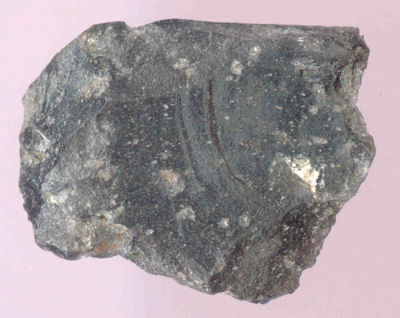
A flake of obsidian from DhRr-18, southern British Columbia. This visually-distinctive glass is from the Mount Garibaldi obsidian source.

Obsidian is a kind of volcanic glass and was highly prized for making certain kinds of stone tools.  Obsidian forms at places of relatively small outflows of magma, or liquid rock.  Small flows can cool quickly, which allows the formation of a glassy crystalline structure ideal for stone tool manufacture.  Small flows also represent a small sample of well-mixed magma, and thus each little patch of obsidian may share a very distinctive chemical signature.  This signature, usually identified by trace elements such as Strontium, Zirconium, Yttrium and Rubidium, then allows for the chemical fingerprinting of each source.  Any obsidian artifact found, whether at a source or not, can also be “fingerprinted” and then compared to a catalogue of known obsidian ources.  Since the artifacts don’t move around on their own but only through the agency of humans, the distribution of obsidian artifacts is a proxy measure for the movement and interaction of people.  When you have hundreds or thousands of such artifacts and a large database of known sources, then you can start to see large scale, long-term social interaction emerge from the silent archaeological record.  Most obsidian isn’t visually distinctive enough to sort out by eye alone, so these geochemical methods are essential.

So far, so Archaeology 101.  I was really happy to find that Oregon’s Northwest Research Obsidian Studies Laboratory has a web site not which not only solicits business, but is a highly educational and informative site about many aspects of obsidian analysis, with a focus on the Northwest. Continue reading

Elfshot: experimental and replicative archaeology

Saqqaq Palaeo-Eskimo flaked stone scrapers and knives, hafted with the aid of baleen. Source: Elfshot.

Elfshot is a cool blog chronicling archaeologist Tim Rast’s replicative and experimental work.  Interestingly to us out here on the NW Coast, a lot of  what he studies and replicates is from the comparable areas of the NE Coast, Newfoundland and the eastern Arctic.  That means he is using some marine sources such as baleen as well as materials such as moose sinew.  There is a lot to read at his blog, which is very well illustrated with photographs, videos, and scans from manuscripts.  If you find yourself in his neighbourhood, you can take courses and workshops on ancient technology from him, and I note that some of his beautiful replications are for sale.

Experimental archaeology is a really valuable approach in archaeology. It helps the archaeologist, who more often than not isn’t part of a traditional materials tool-use culture, understand the constraints of certain materials and likely technological sequences that would have been followed to make and use things.  While perhaps no substitute for observation and interviews, the fact is that by the time ethnographers got to most places in the world many traditional technologies had fallen by the wayside, and so there are very few descriptions of such basic technological domains as flaked stone tools.  Much of what we know about these tools and technologies comes from the work of replicators and experimentalists who set the facts of life out to help analyse the material which comes from the ground in archaeological digs.

Anyway, I strongly recommend Elfshot as a knowledgeable blog offering a lot of archaeological insight, especially for coastal contexts.

Use of the "mystery tool type" - piece esquillee - as a wood-splitting wedge. Source: Elfshot.

Annotation: Collison Bay

Annotation of the Collison Bay night-time, low tide excavations.

The Collison Bay site in Haida Gwaii  posed some unusual challenges, some natural and others of our own making.  The site is found in the intertidal zone and dates, like the Kilgii Gwaay site about 10 km away, to a brief window about 10,700 calendar years ago.  I posted the above picture before, but without annotation.  That previous post describes something of the site formation processes, which mean a site which was terrestrial when occupied is now in the intertidal zone, and excavation must take place between the tides.

Looking at the above, you can see we didn’t plan for the tides very well!  other projects required us to be elsewhere and when it was Collison Bay’s turn, the low tides were in the middle of the night.  This meant we had to get up at midnight to work until about 6.00 in the morning the first night to catch the falling tide, then we got up about 12.45, then about 1.30, and so on: tracking the procession of the low tides.  So, to the inherent complications of working in the intertidal zone we did it in the dark, running electric lights from a generator.  This actually worked really well and data recovery was excellent – we dug there on another occasion in the daytime (see below) and there was no real difference in quality of work.  Also part way through this project we were working until mid-morning and could see pretty well!

The site includes numerous water-worn stone tools on the surface and in the upper beach deposits, but in the lower beach deposits the tools are pristine and show no signs of water-rolling.  In many cases they lie flat, also suggesting a lack of disturbance, and they are encased in a thin, brown layer of jelly-like material which is the organic remains of a degraded soil.  Unlike at Kilgii Gwaay, there is no survival of bone or wood.  Nonetheless, the stone tools are very similar to that site, and speak to a terminal Pleistocene technological approach using discoidal and uni-directional cores to create large blade-like flakes.  Too much information for some readers I bet – but the take home message is this way of making stone tools might be peculiar to the  Pacific Rim and not the continental interior and therefore might, perhaps, maybe, one day, turn out to have significance for the coastal route of the First Peopling of the Americas.

Pristine, sharp blade-like flakes used as stone tools from 10,700 year old deposits in the beach at Collison Bay. Flake on right is about 6 cm long. Photo: D. Fedje

Establishing an excavation unit as soon as feasible on a falling tide to maximize digging window.