Monthly Archives: March 2010

Vanishing Eulachon

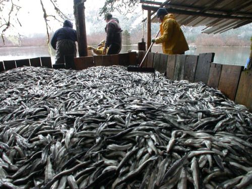
Eulachon. Source: Sitnews.net

I often use eulachon (Thaleichthys pacificus, a small, anadramous smelt) as an example of “archaeologically-invisible” food. They are also known as “candlefish”, on account of being so oily that a wick jammed down their throat will burn like a candle.

These small fish run by the millions up rivers to spawn, where they could be intercepted.   Traditionally, many or most eulachon would be processed into eulachon oil, or grease: a highly nutritious, calorie-dense substance that preserved very well and could also be used to preserve other foods such as berries.  The means of processing was to put them into a large container, perhaps an old canoe, known colloquially as a “stink box”, let them “rest” there for a week, and then heat them up, enabling the oil to rise and then be skimmed off, or pressed out.  The residue (bones, guts, brains, etc.) would then be returned to the river and few or no bones would make it away from the processing site.  In this way, eulachon provided a staple food, a nutritional supplement, a means of preservation, and an extremely valuable trade item – when Alexander Mackenzie arrived near Bella Coola in 1793, “Over Land, From Canada”, he did so on one of the well-worn grease trails that linked coast to interior. Since the fish arrive in the early Spring, they were hailed as starvation busters in lean years.  Nonetheless, archaeologically they are almost invisible, relative to their importance.

Haisla eulachon catch from the Kemano River. Source: living landscapes.

It is therefore sobering to read that U.S. President Obama has listed the Columbia River eulachon as an endangered species: eulachon are becoming almost invisible relative to the real world now, it seems.

Continue reading

Northwest Research Obsidian Studies Lab

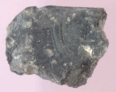
A flake of obsidian from DhRr-18, southern British Columbia. This visually-distinctive glass is from the Mount Garibaldi obsidian source.

Obsidian is a kind of volcanic glass and was highly prized for making certain kinds of stone tools.  Obsidian forms at places of relatively small outflows of magma, or liquid rock.  Small flows can cool quickly, which allows the formation of a glassy crystalline structure ideal for stone tool manufacture.  Small flows also represent a small sample of well-mixed magma, and thus each little patch of obsidian may share a very distinctive chemical signature.  This signature, usually identified by trace elements such as Strontium, Zirconium, Yttrium and Rubidium, then allows for the chemical fingerprinting of each source.  Any obsidian artifact found, whether at a source or not, can also be “fingerprinted” and then compared to a catalogue of known obsidian ources.  Since the artifacts don’t move around on their own but only through the agency of humans, the distribution of obsidian artifacts is a proxy measure for the movement and interaction of people.  When you have hundreds or thousands of such artifacts and a large database of known sources, then you can start to see large scale, long-term social interaction emerge from the silent archaeological record.  Most obsidian isn’t visually distinctive enough to sort out by eye alone, so these geochemical methods are essential.

So far, so Archaeology 101.  I was really happy to find that Oregon’s Northwest Research Obsidian Studies Laboratory has a web site not which not only solicits business, but is a highly educational and informative site about many aspects of obsidian analysis, with a focus on the Northwest. Continue reading

Edenshaw Compote

Argillite and ivory compote attributed to Haida master carver Charles Edenshaw. Height: 30 cm. Source: Liverpool Museum.

I only have a short post today since I am up to my neck in alligators, courtesy of my day job.  So, take a moment and check out the spectacular argillite compote (a pedestaled serving dish), attributed to Haida master carver Da.axiigang, Charles Edenshaw.  This particular dish is in the collection of the Liverpool Museum – an institution that  holds a collection donated by well-known coastal collector, casual ethnographer, and (apparently) former Liverpudlian, Dr. Charles Newcombe – many of the items in their Northwest Coast section must come from this source.  It is one of the more striking pieces of Argillite I have seen in that the form is so clearly derived from silverware: it is sublimely ridiculous, and I can’t help but feel that Edenshaw was in on the joke.  Yes, he would make what would sell, but a piece like this makes me wonder if he wasn’t slyly pulling the touristic leg, somewhat.

Continue reading

Salish Villages of Puget Sound

Overview map of Coast Salish Villages of Puget Sound. Click to go to the page of interactive maps at coastsalishmap.org

Tom Dailey has put together a large and very interesting site which documents the Coast Salish villages of Puget Sound.  The core of the site is a series of clickable maps (see the left hand side black/white map grid), each of which is marked with little village icons.  Clicking on these icons takes you to a master document with a synopsis of the settlement name and, usually, a couple of sentences about the village.  These are referenced to scholarly literature and other sources.  It is striking to see all these villages on one map, and notable how many are shown on rivers and lakes.

Continue reading

Arrow from Tsitsutl Peak Glacier, Western B.C.

400 year old arrow or dart from Tsitsutl glacier, B.C. Source: Keddie and Nelson: 2005.

In 1924, a land surveyor found an arrow at an elevation of 2,100 metres near Tsitsutl Peak in west-central British Columbia (map).  The arrow made its way to the Royal BC Museum where it lay for over 80 years, until a timely inquiry and increased awareness of ice-patch archaeology stimulated a small research program.  This research, initiated by RBCM curator Grant Keddie and reported in the Canadian Journal of Archaeology (Keddie and Nelson 2005), establishes that the arrow is about 400 years old.

Continue reading

Webber’s Village in Nootka Sound: Original Watercolour

Painting of a village in Nootka Sound, 1778, by John Webber. Source: State Library of New South Wales. Click for larger original.

Yesterday I linked to the original watercolour of a 1778 Nootka Sound house interior by John Webber, which is the basis for the widely reproduced engraving.  Today we can take a look at Webber’s original painting of a Nootka Sound village, presumably Yuquot but not so labelled, as found at the State Library of New South Wales (though yesterday’s post brought forth questions as to whether these are watercolours or coloured engravings – see the comments).  The first and most important point is, see that lumpy, dissected landform in front of the houses?  That, my friends, is what an active shell midden looks like.  No wonder they can be such stratigraphic nightmares.

Continue reading

Webber’s House Interior: Original Watercolour

1778 Watercolour by John Webber of the interior of a house in Nootka Sound. Source: State Library of New South Wales. Click for original.

A few days ago I posted a beautiful watercolour of Nootka Sound by John Webber, artist on Cook’s third voyage.  In the ensuing discussion, it was brought up how nice it would be to see the original watercolours of more of his paintings, which often formed the basis for the  numerous engraved reproductions which are what one normally sees.  The loss of information in moving from the original to the engraving is something of an unknown quantity, and I for one had never seen the watercolours.  Until yesterday!

Continue reading

Puget Sound Clovis

In Red: Surface Finds of Clovis Projectile Points. After Croes et al. 2008.

I posted yesterday about the Manis Mastodon site and its possible status as a pre-Clovis site on the Olympic Peninsula.  Clovis projectile points are so distinctive that most archaeologists have no problem assigning even an isolated find of such a point, lacking in any kind of stratigraphic context or any associated dates, to the Clovis archaeological culture.  We know from sites elsewhere in North America that Clovis dates to a pretty narrow window, perhaps only 13,200 to 12,800 calendar years ago.  It has always been very closely associated with the ice-free corridor route for the First Peopling of the Americas and is predominantly known from classic sites in places like Colorado, New Mexico and Texas. So it may come as a surprise to some that Clovis is pretty well represented in Puget Sound and north to Bellingham Bay, although only from surface or other finds without provenience.

Continue reading

Yank that sucker out!

Mastodon rib from Manis site, showing protruding end of an intrusive object. Source: CSFA

The Manis Mastodon site near Sequim on the Olympic Peninsula (map) is one of the great enigmas of Northwest Coast archaeology.  The site has been known since the 1970s and is purportedly a Mastodon kill-butchery site.  With radiocarbon dates (on plant material associated with extinct mastodon) of 13,500 to 13,900 calendar years ago, the site is clearly pre-Clovis.  As a pre-Clovis site on the Northwest Coast, Manis  should be of comparable stature to, say, the Clovis-killer Monte Verde site in Chile, which dates to about 14,500 calendar years ago.

Doubts remain about this site, though, mainly because it is not yet completely reported.  A preliminary report by Gustafson et al. in the Canadian Journal of Archaeology (which I don’t have handy — hey CAA, I know you sell CDs of your back issues, so how hard can it be to put them online?) was equivocal about the association of some flake and cobble tools with the skeleton, and while interesting conclusions were drawn about the fragmentary nature of the skeleton, nothing conclusive was resolved.  This is despite one of the clearest possible “smoking guns” one could hope for in archaeology.

Continue reading

Association for Washington Archaeology

9,000 year old stone tools from Colville National Forest, Washington. Source: The Spokesman-Review.

I was a little surprised (and probably shouldn’t be) to find out there was an organization called the Association for Washington Archaeology – equivalent to the Archaeological Society of B.C.  They have a journal (equivalent to The Midden), and are clearly a respected avocational archaeology organization.  They have a pretty low profile, obviously: but partly this must be another symptom of the poor cross-border communication between BC, Alaska, Washington, and Oregon  – the core jurisdictions bounding the Northwest Coast.  They even have a blog called Washington Archaeology, which is only a few weeks old.  Their own link to it is both hidden under a “feedback button” and is broken: I hope that linking it here helps people find it.  There’s not much there yet, but it did lead me to a nice news roundup on the Tse-whit-zen site, and also to an interesting story on a 9,000 year old site in the Colville National Forest, near a town called Republic – just south of the Canadian border close to Grand Forks BC. (map).  Continue reading