Tag Archives: Kwakwaka’wakw

Houses on Stilts

"Village of the Friendly Indians at the Entrance of Bute's Canal", 1792. Click for zoomable version.

The above image shows a seemingly improbable Kwiakah Kwakwaka’wakw Village (EDIT: probably Homathko Coast Salish Village) at the entrance to Bute Inlet, as drawn in 1792 by a member of Captain Vancouver’s expedition.  With the houses scattered up a steep hillside, the top one apparently partially cantilevered out, it does not fit the average archaeologist’s mental model of a typical Northwest Coast village.  The setting would undoubtedly have some defensive advantages, at least for those at the top.  I know of another image of a steeply-tiered village site which is apparently not strictly a defensive site.  Hard to live on the side of such a steep hill, you might think.  Wouldn’t it be nice to have photographs of such a village?  Aha.

Continue reading

Destruction of Kwalate Village

Major landslide scar near Kwalate Village. Source: panoramio user Obslord.

Yesterday’s post about Marianne Nicolson’s powerful pictograph in Kingcome Inlet and the post from a few days ago about the enormous Tsunami in Lituya Bay got me thinking again about recent work in Knight Inlet on the central B.C. Coast (map).

A recent project by a team of geomorphologists and an archaeologist, UVic’s own Duncan McLaren, investigated oral historical accounts about Kwalate Village of the A’wa’etlala and Da’naxda’xw peoples, of the Kwakwaka’wakw First Nations.  The accounts state that a landslide in Knight Inlet triggered a local Tsunami which swept this village away. This account is known anthropologically through a number of sources, including Franz Boas (1910, Kwakiutl Tales):

“About three generations ago, or possibly at an earlier date, a large portion of the mountain opposite Kwalate Point slid into the inlet causing a huge tidal wave which wiped out all of the inhabitants of the village opposite…and the vast slide is noticeable today”.

Of course, the story of the destruction of Kwalate is still told and the dead, unknown in number but perhaps up to one hundred, are still mourned and memorialized in the surrounding communities.  While it is not necessary, or even desirable or possible, for archaeology to confirm oral historical accounts, when that happens it can be of interest to archaeologists and First Nations people alike. Continue reading

Cliff Painting by Marianne Nicolson

Marianne Nicolson is a member of the Dzawada’enuxw Tribe of the Kwakwaka’wakw First Nations.  She is an internationally-known contemporary artist, and a Ph.D. candidate in the Departments of Linguistics and Anthropology at the University of Victoria.  Her work is outstanding and profound and if you get a chance to see her studio pieces, then by all means do so.

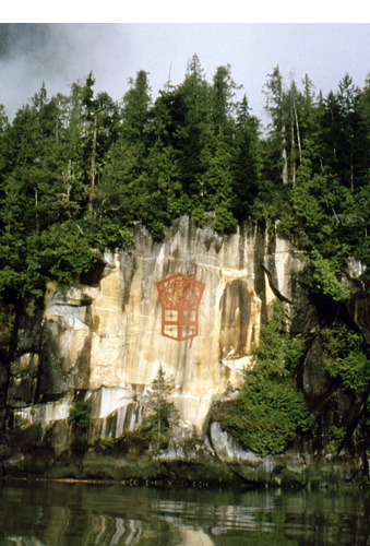
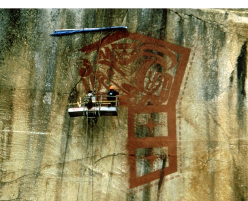
One work you will not be seeing in a gallery anytime soon is her massive pictograph, Cliff Painting, near the head of Kingcome Inlet in her traditional territory (map).  The work is over 15 metres high by 10 metres wide, emblazoned on a prominent cliff as you round the final corner heading into Kingcome (video, scroll down).  It formed the focal point of the book by Judith Williams Two Wolves at the Dawn of Time, which is highly recommended.  Painted using scaffolds lowered from above the cliff, the work is a profound statement of power and energy.  The image is of a “copper“, a large shield-shaped symbol of chiefly power, family prestige and spiritual inheritance, among many more nuanced meanings.  Many pictographs on the coast are fading away, rinsed by sun and rain, vandalized even.  This massive pictograph takes a stance for all the past, present, and future powers of the Kwakwaka’wakw First Nation.

Cliff Painting in Progress. Source: The Medicine Project.

Tree Burials at Tsaxis

"Arriving for a tree burial by canoe, in British Columbia, a traditional Indian ceremony", c. 1920. Watercolour by Joanna Simpson Wilson.

One of the most distinctive burial methods on the Northwest Coast was the creation of platforms in trees, on which coffins would be placed.  While the practice is commonly recorded and discussed in the Anthropological literature, photographs of tree “burials” are rare — and even if they were not, then reproduction of these images might well be problematic.

I recently ran across the image above by the little-known Canadian author Joanna Simpson Wilson (1896-1987), which shows numerous bentwood boxes attached to trees as a throng of mourners gathers below.  The platforms are rather insubstantial and the coffins are stacked several-high in places, with red cloth attached — perhaps the remains of blankets.  After a number of years, the boxes would deteriorate and the remains of the body would fall from the tree.  At this time, a secondary burial at a village site cemetery or other place might be performed.  I have seen the remains of several tree burials in the field, with human remains scattered beneath the branches of a large spruce — looking up, there are large branches with ring-like pathologies where the bark grew around rope, and other evidence of cultural modification. Archaeologically, there is a trend over the long term along the coast for inhumation of human remains to give way to sky burials or mortuary houses.

According to this site, the setting of the painting is the Kwakwaka’wakw village of Tsaxis (near Fort Rupert / Port Hardy on Vancouver Island), specifically a place called Storey Beach (more pics).

Boas 1934: Geographical Names of the Kwakiutl Indians. Click to enlarge. Strangely, Tsaxis (#13) is not plotted on the map.