

Lidar model merged with photograph to document carved pole, Sitka, Alaska. Source: National Park Service.
This is an interesting application of Lidar technology – creating a durable, highly precise, digital image of a standing pole, which can then be wrapped with high-resolution photographs and used in a “virtual tour” context. It can also be an archive for conservation. The project is underway to record a couple of dozen Tlingit poles in an outdoor setting in Sitka, Alaska.
Lidar stands for “light distancing and ranging” and is basically like radar or sonar, only using laser beams. Thousands of individual laser bursts can measure the three-dimensional surface of something like a totem pole to accuracy of a millimetre or less. This creates an accurate digital record of the shape of the pole which can then be rendered on-screen in various three-dimensional ways. Lidar has seen a fair bit of use in archaeological survey (especially its ability to digitally clearcut the trees) and also has seen quite a bit of table-top use to record artifacts in exquisite detail. The “meso-scale” recording of features like poles is less common though, especially outside of historical and classical archaeology. There is a lot of potential for recording petroglyphs I think — for example this recent dissertation (which I need to order) apparently shows proof of concept at Writing-On-Stone in southern Alberta.

Sitka Pole lidar gadget. Source: KCAW.org
The lidar device for the pole application is about the size of a breadbox (see above) and can be mounted on a tripod, or on rails/scaffolding. This audio interview and brief writeup tells us more about the Sitka case study, which is seemingly part of a larger historical scanning project in Sitka. I should add that we saw in passing, way back on this blog, a similar lidar+photo rendering of a Yukon paddlewheeler (see below). The value of these models is, I suppose, that they provide a highly accurate baseline from which to monitor deterioration. Further, if push came to shove, you could use the model to simply 3-D print out a new pole, or steamship.
My first thought was that it would be a very cool and useful project for the Haida Village of SGan Gwaay – one of the few places left on earth where poles still stand in numbers. I see that the idea was mooted as long ago as 2004, with the support of former President of the Haida Nation, Guujaw. Still, I don’t think anything happened about that, and I’m not even sure the single pole scan described in the article even happened. Maybe someone reading this knows.
It’d be a pretty sexy project for Parks Canada to undertake and it might not even be all that expensive. I could imagine a nice Parks-Haida Nation partnership with industry doing the scanning, and a University providing on-site beards and gravitas. Let’s get on it!
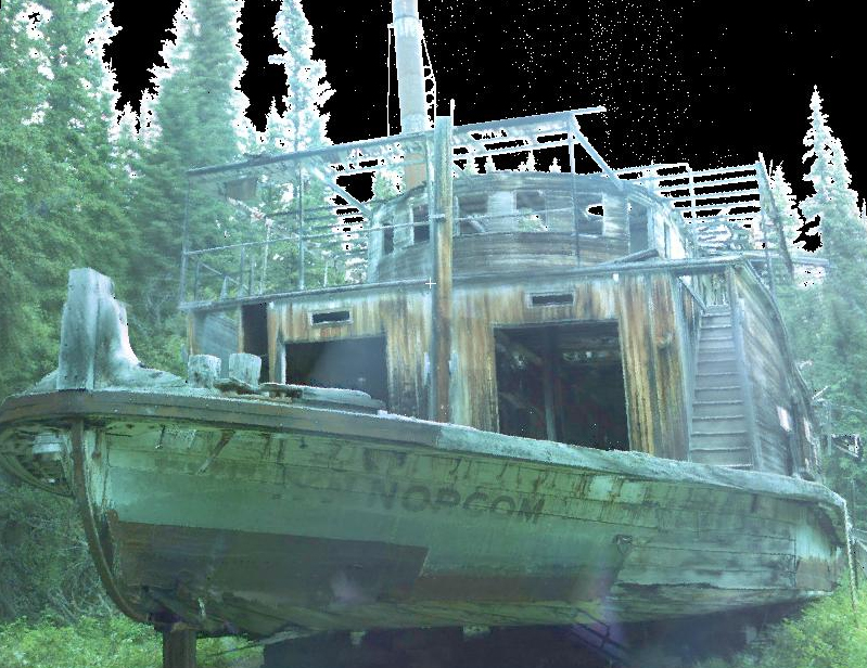
Photo draped over LiDAR model of a Yukon paddlewheeler Source: INA


I’ll take the photographs!
LikeLike
And, thanks for the link! I think these kinds of technologies are going to transform certain kinds of archaeology. I know of a small stone building that needs this treatment, if it were affordable. So much more precise, and quicker, than hand drawing walls and floors…
LikeLike
Hi ehpem – ok, photographer position filled! Beard position filled! Now we just need laser person and money person and garlic-butter-halibut-fry-up person.
Yeah, it’s transformative technology. I wish I had dived in more headlong in about 2005 when we started tinkering with this stuff for karst survey amongst other things. It proved it’s worth on Argonaut Hill, N.E. Haida Gwaii, maybe I will make a post about that. And I think the central coast team is going to do some great stuff with it. This intermediate scale stuff sort of falls between the cracks. Recording petroglyph park or the Gabriola sites this way would be of lasting value as well as just be cool, if the First Nations were onboard and interested.
LikeLike
Non-destructive, non-altering technology. Many First Nations would be very interested. And, to go back in 10 years and replicate to see if weathering and so on can be identified and modelled. Could be a very cool application. And, no permits needed if no alterations take place. Though, that could keep the results locked up in a cupboard somewhere that other archaeologists could not see, so publication would be a necessity too….
I bet the data could even be used with a computerised cutting machine, or similar, to make exact replicas for museums and display. Better than a rubber mould and fibre glass cast in many ways.
LikeLike
Perhaps I can be the money finding person AND the garlic-butter-halibut-fry-up person. Inquire within.
LikeLike
Funny that you should post this now- just last week Chris and I were discussing almost that very project, except using photogrammetry to get the digital models rather than laser scanning. There’s a fellow in the States using that method to monitor rock art degradation (http://palentier.blogspot.ca/2011/11/determining-rock-art-deterioration.html), and it seems like a good way to go. Photogrammetry has some advantages over lasers in that it doesn’t require $10K+ of equipment and is pretty easily scalable, so you can 3D-capture anything from massive landscapes to poles to itty-bitty artifacts (ie. microblades) using the same kit.
The twitter-ized methodology for degradation monitoring is: create the 3D pointcloud (using lasers or photogrammetry) and transfer it into a GIS program as a ground surface. Do the same a year (or whatever) later. Match up the two rasters. Run a raster calculator in the GIS program to identify surface differences.
Should you be open to trying the photogrammetric approach, I’ve been tinkering with it a bit and I think I could be persuaded (without too much difficulty) to head back to Sgan Gwaii as 3D Capture Person. Give me a week and I’ll pitch in a beard too.
LikeLike
I’ll match the beard. And raise you to a grey-beard.
I have been fooling around with some photogrammetry, but using free software which does not really cut it (123D Catch – tons of uploading issues). Though when it works it makes a nice wire frame model of the object at a moderate resolution. Here is an example, I never managed better than this, but should be able to: http://www.youtube.com/watch?v=5DS29-yfWRI&feature=youtu.be
The commercial software I have looked at seems to run about $7k, but works from very few images. Whatever is done on a project, the right kinds of high res photos should be taken from the right places and in sufficient quantity to cover off future applications
LikeLike
@ehpem: Yeah, I’ve tried 123D Catch and HYPR3D, but I also found the uploading to be a pain (not to mention issues surrounding potentially culturally sensitive digital materials being stored on a server somewhere). I’ve moved towards Bundler/SFM-based opensource software lately and have had some better results than I got from 123D Catch. Installation itself is often a challenge, but once it’s there (and the camera calibration is done) it seems to work quite nicely. There’s a Linux operating system with preloaded software geared specifically for archaeology that includes a suite of scanning/photogrammetry stuff. So far I’ve been impressed. Available here: http://www.archeos.eu/wiki/doku.php/ It will work in a virtual machine (ie. Virtualbox or VMWare) so you can run it within your extant OS.
LikeLike
Brings up some interesting discussions about replicas and cultural ownership as well…
LikeLike