
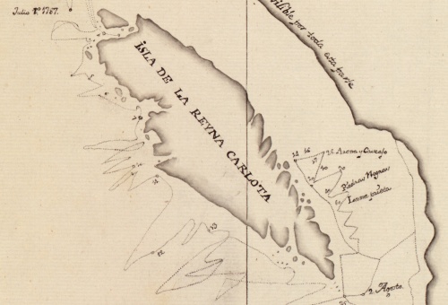
Dixon’s 1787 map showing Haida Gwaii as an Island. Source: Library of Congress
Old Maps are Cool. Enough said. Or maybe not quite enough.
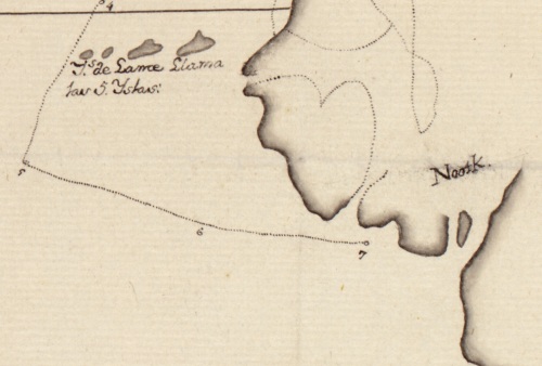
Dixon 1787 Showing Nootka Sound (sort of)
The Library of Congress has some nice documents online, and they don’t skimp on the resolution. You can download Captain George Dixon‘s 1787 map showing Haida Gwaii as an Island for the first time – the formats range from a small JPEG to a 100 meg TIFF. I tried the larger JPEG first but the TIFF allows much crisper detail and the ability to actual read the writing on this map. I don’t know what the “Islands of Lama Slama(?)” are – I am sure someone does – too close to Nootka to be the Cape Scott islands — maybe it’s the south side of the Brooks Peninsula misinterpreted as islands. And why is it in Spanish? Fill me in.

Langara Island and Dixon’s Entrance, July 1, 1787.
It’s also cool to see the tacking back and forth of the ship.
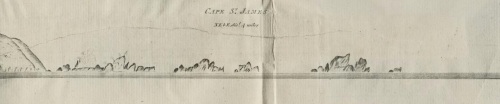
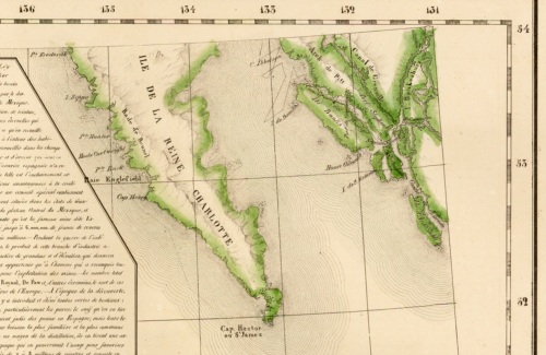
Dixon 1787 Cape St James and Kerouard Islands sketch – the southernmost tip of Haida Gwaii.
Dixon put his round the world trip into a book you can read online at UBC, or download at the Internet Archive.
Description of Haida Gwaii, which “surpassed our most sanguine expectations”
Anyway, I have a file on my computer (below) with the name “Haida Gwaii 1800-ish” — I don’t know where this came from and google image search doesn’t help. If anyone knows the origin of this cool map, let me know. It’s a fascinating document, showing Langara Island far bigger than it is, and Massett Sound passing right through the archipelago (it doesn’t – they may have mistaken an oral account of Skidegate Channel which does come to the west coast about at that place). It shows “Port Cumshewa” and “Port Skittigate” in about the right locations, and the big embayment to the Southwest called “Maggie’s Sound” and “Port Perkins” must be Tasu or Gowgaia. The legend says the map is sources to a Captain Maggie from Boston. I tried looking it up but my attention span is not that great and probably it’s a famous map someone recognizes. So have at it.
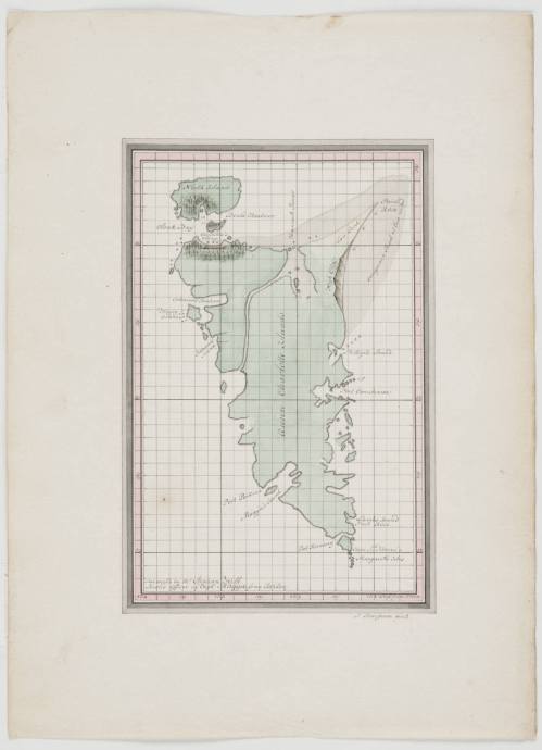
Haida Gwaii “1800-ish” map.


That map fits the description for one by Sigismund Bacstrom in this document (PDF).
LikeLike
I think that’s it, in the link you posted (Douglas Cole on Sigismund Bacstrom in BC Studies) there is this:
LikeLiked by 1 person
Thanks for cleaning up the link, and digging out the relevant part. It was too much for me on my phone in the middle of the night.
LikeLike
This is another unusual map, from Vandermaelen’s 6 volume atlas, Brussels, 1825. The whole map is available for download here (button on lower right of the image box). There’s a huge slab of text in French and not much actual map.
It’s worth taking a minute to think of how each of these maps literally sketches out increasingly detailed versions of the colonial project – they’re the user guide to the appropriation / expropriation of land and sea.
LikeLiked by 1 person
Further to my last comment, here is a great article from a different part of the world on the constructive and destructive power of maps in an Indigenous context – Zuni Nation, SW United States:
Counter Mapping“Modern maps don’t have a memory ……. ‘More lands have been lost to Native peoples probably through mapping than through physical conflict.’”
https://emergencemagazine.org/story/counter-mapping/
LikeLike
The Bacstrom map is reproduced in Soft Gold, Vaughan and Holm (1982)
Bacstrom was surgeon on the Butterworth, part of a three-vessel expedition from London, headed by William Brown, which was on the coast between 1792 and 1794 with orders to establish a station on the Queen Charlotte Islands. However, Bacstrom transferred to another English vessel, the Three Brothers, at Nootka in 1792. He sailed in the waters of the Queen Charlotte Islands in 1792 and 1793 but in the latter year is known to have stopped at Houston Stewart Channel. His map, detailed but not very accurate, is reproduced in Vaughan and Holm (1982: 230; see also Cole 1980; Kuykendall 1923; Jane 1971: 93).
LikeLike
Thanks Dr Galois!
LikeLike