
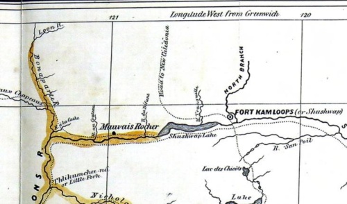
Anderson’s map of the Kamloops area 1858. Note R. aux Chapeaux (Hat Creek) and R. de la Cache (Cache Creek) to west; Shushwap Lake (Kamloops Lake) and the North Branch (of the Thompson River). Kumcheen / Little Fork, just upstream of Spence’s Bridge at the Nicola – Thompson confluence, lower left.
There were a lot of ways to make money from the B.C. Gold rushes which started in the mid 1850s. One of these was to publish a guide book to help prospecters enter the Gold Fields from starting points at The Dalles on the lower Columbia River or at Fort Langley, east of present-day Vancouver. Few were better prepared to write such a guide book (price: $1.50) than Alexander Caulfield Anderson, who had at least a decade of experience surveying for accessible routes into the interior of BC, especially Brigade Trails along which horse trains could pass.
The Gold Rush was, of course, one the of the main spearheads of colonialism and instigated or continued a lot of painful dispossession of Interior First Nations. Anderson’s guide, available online (lower resolution 20 meg PDF direct download) can be read in many ways, but it is a valuable document of a slice of time (it is dated May 3rd, 1858, a watershed year in the history of B.C.), just as the middle Fraser Gold Rush was gaining steam but before the Cariboo Rush of the 1860s. It’s a pragmatic guide that gives landmarks, travel times, names of First Nations’ villages, where to catch sturgeon, how to hire a canoe, and other practical information and, of course, it includes an interesting map on the last pages, showing overland routes into and around the Interior.

Anderson’s 1858 Guide Cover. Note the appended “Chinook Jargon – Language Used – Etc. Etc.” to which Anderson later objected (apparently – see below).
The guide contains a lot of practical information for which it helps to have an idea of the basic layout of the BC interior. A number of the place names have changed through time of course – French to English, First Nations’ place names have changed orthography, and some very confusing changes made from the perspective of now – as in the naming of Shuswap Lake at Kamloops noted above (present day Shuswap Lake is much further to the east).
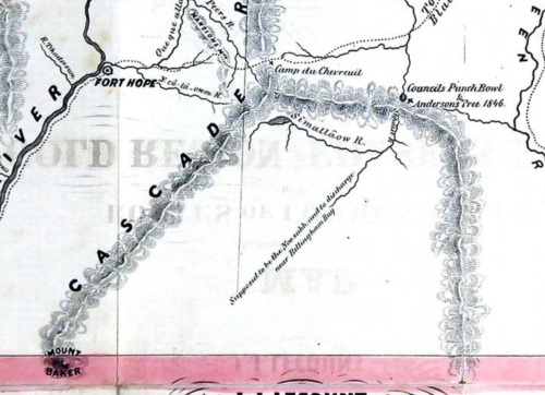
Anderson’s Guide 1858 – Anderson’s tree. Similkameen river on very far eastern edge. River “supposed to be the Nooksack and to discharge into Bellingham Bay” in lower middle. Far west: Hope, and the “Que que alla” River (Coquihalla today.)
In the map detail above, you can see a not-entirely accurate rendition of the Manning Pass area. Of interest is the point in right centre marked as “Anderson’s Tree 1846.” While no doubt at least 5 of my 7 readers knows what this is already, I had to look for it. It turns out Anderson held something of a parlay at this spot in 1846, at which point a kind of “Maypole” was made by limbing a tree to near the top. Even more interestingly, Alex Anderson’s great-grandaughter Nancy has a history blog (!!) and a post on this very tree(!!!). Some of her readers have located a likely candidate fallen tree in a location that fits with Anderson’s field journal – so it seems entirely possible this tree still exists. Now, some of my better informed readers can tell me if a culturally modified tree from 1846 is automatically a protected archaeological site – certainly “pre-1846” is the language one uses but what about the year 1846 itself? You don’t see many, if any, automatically-protected, settler-origin, culturally-modified trees in B.C.
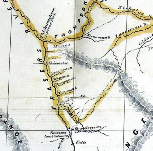
Anderson’s Map: 1858 mid-Fraser. Note the dense place names along this section, already in May 1858 known to be highly productive goldfields. Also note “Anderson’s River” which meets the Fraser just south of present-day Boston Bar. These are all on the left bank of the Fraser, where the trail and portages ran
This section of the map is a good opportunity to make note of a very nice article and accompanying maps in the journal B.C. Studies. The article is “Fraser River Gold Mines and their Place Names by Andrew Nelson and Michael Kennedy (2012), and is open access, as are the two maps (four panels from Langley to Quesnel) at the same link. Below you can see a detail of the same general area around Boston Bar from their map, and gain an impression of the intensity of mining activity, which lingered for decades after the initial rush was over. These two maps are well constructed and absolutely full of detail. At the link above, I believe you can order print copies for around 5$.

Nelson & Kennedy 2012 Map detail: Scuzzy Creek to past Boston Bar,with inset. Again, note Anderson River in lower right. Anderson notes that two bridges were formerly in existence over this river.
There a lot of titbits of interest in the guide itself, like the note above that there were formerly bridges over the Anderson River — today there is a very fragile seeming and high bridge at this point. Perhaps these former bridges were like the ones I talked about here, in a different life. Also, as noted above, there is a section of Chinook Jargon (a widely spoken creole trade language in the Northwest) vocabulary and phrases, for example the very useful selection below.

Anderson Chinook Jargon example phrase.
The version of the guide book which UBC has digitized contains the frantic disclaimer below, in which Anderson denies any connection to what he clearly thinks is a bogus addition at the printing house. For more on non-“flaming” Chinook Jargon, there’s an active blog here. In any case, it’s an interesting book which, like I say, contains dark overtones if you consider it in its full historical context.
(By the way, there are some interesting archaeological studies of the late period and early historic period on the middle Fraser which I will get into in a post sometime soon – Brian Pegg 2012, Jesse Morin et al 2012, and others.)

Anderson Chinook Jargon disclaimer on frontspiece of UBC digitized copy.


OK, so you’ve roused the former bureaucrat that I have been trying to wash away for the past 4 years to consider your “pre-1846” question. I expect bureaucrats and lawyers would argue that pre-1846 means 1845 or earlier. However, since 1846 is a lawyer’s date related to when the Crown asserted sovereignty over what is now BC, perhaps some would argue that 1846 really means “June 15, 1846”. That is the date the Oregon Treaty was signed, and sovereignty was formally asserted. Nancy Anderson mentions AC Anderson being in the area in early June, but doesn’t give a precise date. If the tree was made June 14 or earlier, then perhaps it could be successfully argued that it is deserving of automatic protection under s.13.2.d of the Heritage Conservation Act. Probably it is the only site in BC where such a fine grained distinction would be possible unless there are other campsites with existing features or evidence of this trip and any others that took place with recorded dates in 1846.
LikeLike
And this link below suggests the Treaty, while passed by the US Senate on June 15th, was not ratified by both parties until July 17, 1846, which arguable puts Anderson’s Tree on the clear pre-Treaty side of the divide. (There must be bark stripped trees dated to 1846 so maybe this is settled policy — though if prime stripping is in the Springtime then the same argument might apply.)
https://web.archive.org/web/20091113034143/http://www.lexum.umontreal.ca/ca_us/en/cus.1846.28.en.html
And that is about as much research as I am prepared to do on the Oregon Treaty as cool as it would be to have this dead tree recorded as an archaeological site. Imagine though the confusion between the Maypole Site and the Marpole Site? Students at my day job would gnash their teeth and mournfully howl.
LikeLiked by 1 person
Nice to see the Fraser placer mining maps project getting some notice!
LikeLike