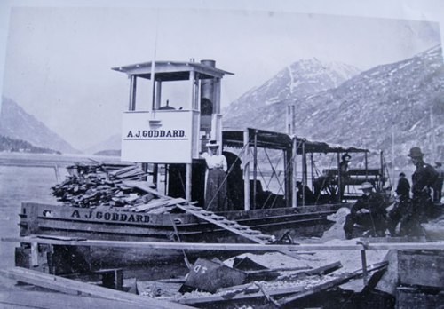
A year or two ago, the well-preserved wreck of the Klondike-era paddlewheeler A.J. Goddard was found in Lake Lebarge on the Yukon River. The find (which is now protected) got a lot of attention because of the ghostly images (click on the very high resolution pop-up ones here) as much as the historical significance. The wreck was recently in the news again because divers had found some vinyl phonograph records which had the potential to be played. Listening to the music of the dead crewmen of a ship evocative of the Cremation of Sam McGee would create close, perhaps emotional, connection with these poor unfortunates.
Being made of stern stuff (heh) what I am more interested in is the intriguing sonar image (above) that accompanied the mainstream press coverage. The phonograph is cool, but archaeologically the more significant development are the new technologies being used on wrecks in general and some Yukon wrecks in particular.
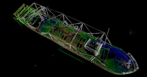
I found more images and a very short article at Wired magazine and they are worth a look, as is much of the background info from the Institute of Nautical Archaeology (INA), which includes a photo gallery. Edit: you can view a nice video of BluView and OceanGate’s sonar model of the wreck here.
For one thing, I had no idea of the scale of steamboat traffic on the Yukon. The INA notes:
When the Gold Rush exploded, forty-three West Coast shipyards responded to the demand, and in 1898, 131 sternwheelers were constructed in yards as far south as San Francisco, and as far north as Dutch Harbour in the Aleutian Islands. In total, 266 stern and side-wheeled steamboats operated on the Yukon River in Alaska and Canada.
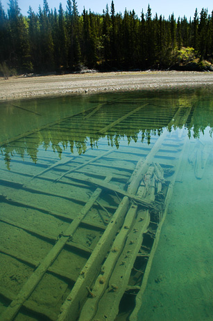
When the boom dissipated in 1900, many steamship companies either went bankrupt or were bought out by competitors, and surplus tonnage was abandoned. Often vessels were left derelict on shore along the banks of the river, where they had been winched out of the water in the fall to protect them from ice damage. As a result, the Yukon now contains one of the greatest intact collections of stern-wheel vessels known, and many are in excellent condition.
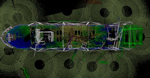
3-D sonar image of the AJ Goddard. The "donuts" are the result of sonar dropped on lines which have a "blind spot" directly below them. Source: Wired Magazine
This isn’t the place to dwell on the specific history of the A.J. Goddard, which went down in a storm with three souls lost. Rather, the advanced sonar used, the Blueview BV-5000-3D, can be deployed on a small remotely operated vehicle (ROV) and via multiple passes over and around the wreck, a highly detailed, highly accurate, three dimensional model of the wreck is derived. As noted, you can view a video of the sonar model here. Very cool. It would take underwater archaeologists with clipboards a while to replicate the accuracy of this 3-D model, though of course the divers can record many more qualitative variables as they go.
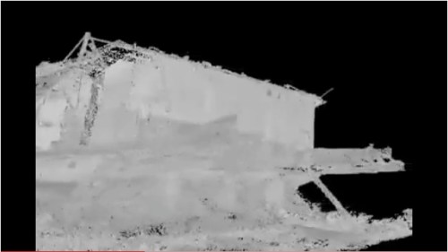
In addition to the AJ Goddard information, the INA has an interesting site about a survey project to record these historic Yukon River vessels, which includes an un-narrated video showing the “point cloud” of an innovative use of LiDAR technology to map the abandoned hulk of the Yukon paddlewheeler Evelyn, more images of which can be found at the INA photo gallery.

I'm not totally sure how this image was generated, it may be a photo draped over the LiDAR model. Or, it may be a long-exposure night time photograph. Anyway, it is pretty great. Source: INA
LiDAR stands for “light distancing and ranging”, and is basically radar, only using laser beams. It allows scanning of a three-dimensional shape – it can be used from aircraft to make a model of a landform, or on a table top to record the size and shape of artifacts, or at an intermediate scale then buildings or other structures, such as this shipwreck, can be recorded quickly and to very high accuracy. Over 150 million laser data points give a three dimensional model of interior and exterior of this wreck. The video gives a good idea of how three dimensional models can be rotated and “entered” to reveal structure. Water conditions would need to be very clear to replicate this underwater, but then, as seen below, they may well be on occasion. The advanced sonar is more likely to be of general underwater use. More details on the LiDAR survey of the Evelyn is here.
So – the phonograph record is cool, and I hope to dance to its sweet tones one day*, but really, the advances in archaeological imaging exemplified by these Yukon wrecks is really astonishing.
Oh yes, the allusion to the Cremation of Sam McGee. This is a poem which all Canadian schoolchildren learn (or should at the risk of a stern paddlin’ themselves), which tells of the fulfillment of a dead miner’s last wish: to be cremated. This wish is made possible in the poem by the discovery of an abandoned hulk, and the subsequent use of its boiler room for unsavoury task. An excerpt:
There are strange things done in the midnight sun
By the men who moil for gold;
The Arctic trails have their secret tales
That would make your blood run cold;
The Northern Lights have seen queer sights,
But the queerest they ever did see
Was that night on the marge of Lake Lebarge
I cremated Sam McGee
[ . . .]
And every day that quiet clay
seemed to heavy and heavier grow;
And on I went, though the dogs were spent
and the grub was getting low.
The trail was bad, and I felt half mad,
but I swore I would not give in;
And I’d often sing to the hateful thing,
and it hearkened with a grin.
Till I came to the marge of Lake Lebarge,
and a derelict there lay;
It was jammed in the ice, but I saw in a trice
it was called the Alice May,
And I looked at it, and I thought a bit,
and I looked at my frozen chum;
Then “Here”, said I, with a sudden cry, “is my cre-ma-tor-eum”!
* not really.




I enjoyed your article. It might be more appropriate to link to the source of the BlueView images and give credit where credit is due. I would suggest you use the link below where the article comments on this new emerging underwater survey technology.
http://www.opentheoceans.com/goddard/overview.htm
Wired.com only wrote a short article…they are not the source of the images.
Cheers,
Doug
LikeLike
Hi Doug,
Thanks for the tip. It looks like Wired in essence wrote up a press release, in which case any publicity is what the company wants. I do think though the web site you mention is a really useful addition to this post and I will insert it into the post itself. The video/animation of the sonar produced by BluView in the course of a project led by the INA really gives a sense of what the technology can do.
http://www.opentheoceans.com/goddard/overview.htm
Thanks again!
LikeLike
Q; the image that you aren’t sure about the technique involved is almost certainly the point cloud with points showing the colour values obtained by a digital camera. LiDAR scanners usually take simultaneous digital photos while they scan, which are automatically calibrated to the point cloud. But the scanner also reads qualities of the signal bouncing back and assigns material type/colour etc to each point based on very sophisticated remote sensing technology; in this way all the ‘vegetation’ can be quickly stripped away if desired, or all the wood and metal elements left. The point cloud in itself is wonderful and can be used to make detailed measurements etc, but to be really useful it needs to be turned into CAD-type objects, and that next step of course takes up a huge amount of time and effort.
LiDAR scanning will certainly revolutionize the way archaeological field recording is done. At Millennia Research we have used it on a couple of projects over the last two years. Feature mapping can be done in unbelievable detail. National Geographic a few months ago had a story about a 15th or 16th Century treasure ship discovery on a diamond-mining beach in southern Africa. De Beers paid for a complete excavation with full LiDAR scanning of the wreck at all stages of excavation. It will be interesting to see what they do with all that spatial data!
The LiDAR scanning of the Evelyn should allow for long-term measurement of its aging and degredation. Sagging and bowing can be measured to the millimetre along each rib, beam, and plank by taking repeat scans over the years; probably allowing problems to be identified before they become visible to the naked eye, and decisions can then be made about conservation.
Can UVic archaeology please buy one and loan it out from time to time ? 🙂
LikeLike