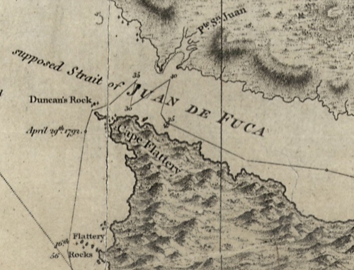
Detail of Capt. Vancouver's 1792 chart showing the "supposed strait of Juan de Fuca". Source: viHistory
vihistory is a web site designed to aid in historical research of Vancouver Island, at which it succeeds admirably. You should poke around and have fun with their census data and the other worthy, if dreary, pursuits it affords the serious scholar.
One feature which is not immediately clear on first glance, perhaps deliberately as has entertainment potential, is a large selection of very high-resolution maps and images which you can download from this page. The file sizes are large, of course, but increasingly that is less of an obstacle in the past. The maps are mostly of historic Victoria, but there are some regional maps such as telegraph and lighthouse maps of British Columbia, and a couple of maps of Nanaimo. As usual, I have surfed through the maps so you don’t have to – and some of them are remarkably fun, and informative.
For example, the above detail form a well-known 1860 diorama of Victoria and environs nicely shows the Songhees Village on the west side of the Inner Harbour. It might be worth comparing to the high resolution 1859 photographs I posted a few weeks ago, some of which are taken from “Church Hill”, presumably to the upper right.
The same “Indian Village” can be seen in the above hand-written annotation twelve years later, 1872. If you know Victoria, this is where the Blue Bridge now crosses. Interestingly, there is a “Lunatic Asylum” shown right beside the Songhees Village – presumably now the Shutters Development. Plus ca change.
A few decades further on, and the reserve is thoroughly dissected, with the “Headquarters of the Sealing Fleet” parked offshore, in the detail above from a 1902 transportation map of Victoria’s Streetcar Network. Fragments of this transportation systems rails remain on Store Street, as late night, high-heeled, drunken revellers leaving the Canoe Club have discovered, I am told. This map is quite attractive and worth downloading for aesthetics alone – the thumbnail doesn’t do it justice at all.

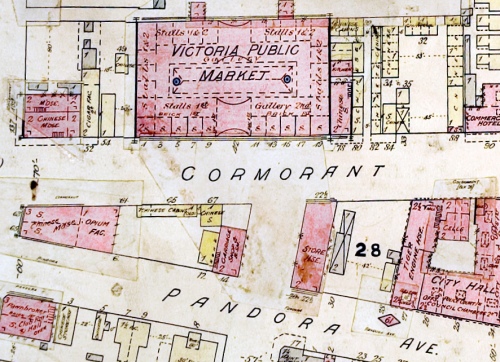
Detail of Cormorant and Pandora Streets, 1891 Fire Insurance Map. Source: viHistory. Click to enlarge.
The above map detail shows, among other things, a fine-looking (presumably Chinese) public market on the current Centennial Square, which was the heart of historic Chinatown. Note the “Opium Factory” marked to the centre-left: very Victorian, really. These Fire Insurance maps are a lot of fun: its worth downloading the large mosaics and slowly panning around your favourite haunts. Who knew 800 block of Broughton Street was called Kane Street and 800 block Courtenay was called Rae Street? etc….
Of course, the purpose of these hyper-detailed Fire Insurance maps was to assess risk and compensation, as the one below with many fire hazards noted, shows. That one is more or less the site of Capital Iron at the foot of Chatham Street. I haven’t linked to any Nanaimo maps (nothing personal) but there are a number of them as well at the maps download page. This is a great site overall, especially the maps – what a great thing to have these down-loadable at decent resolution that allows the details to be read. It was put together by professional historians at UVIC and VIU, but probably has interest for archaeologists as well as the more papery disciplines.


My great great Aunt Flora Ross was the matron of the Lunatic Asylum. She was youngest daughter of Charles and Isabella Ross, builder of Fort Victoria and first Metis HBC family of Victoria in 1843.
LikeLike
fern — glad to hear from you, and such a lucky small coincidence to put a name and context onto the tiny, smudgey little notation on that map.
Speaking of coincidences, the Patron Baby of this Blog (PBB) is a four month old also named “Flora”.
LikeLike
Hi Fern,
I clicked on your name and found your blog which is very interesting to me, not least because I live within the boundaries of Isabella Ross’ original land holding.
Since this is an archaeology blog, it is nice to tie Isabella Ross together with NWC archaeology. So, as far as I can tell about the boundaries of the property that she owned from 1855, there are now at least four archaeologists that live within those boundaries. As well, the “PBB” Flora that qmackie mentions also lives in the boundaries of the original Ross property.
There are at least 6 recorded archaeological aboriginal sites within those same boundaries, and likely a number more that have not been recorded or that no longer exist due to development. These include a village site, several camp sites, burial areas and some inland hunting or harvesting sites.
LikeLike
Fascinating…Isabella Ross was French Canadian Metis and Ojibway from the Island of Michilimackinac in Lake Superior District… it is amazing she was able to be the first woman landowner in BC and a Native woman at that! Her late husband did not leave her anything in his will but the clothes on her back…and provisions for the children…she traded farm produce with the local Tribes…she did own Rossville farm with her son John in Nisqually, WA between 1846-1853…it is now Fort Lewis Military Base golf course.
LikeLike
qmackie, how is the Patron Baby ‘Flora’ growing? She must be close to a year by now!
An acquaintance, who is a practicing psychiatrist, tells me that Flora Ross, the Matron of the Asylum at Songhees, was credited for the development of a more humane strait jacket. She was also commended for her humane treatment of patients, arranging outings for them and treating them with kindness. She eventually assumed the position of matron at Woodlands in New Westminster and was commended for her work there, after overcoming racially based persecution.
LikeLike
Pingback: Water Keeper « burnt embers
Hi fern,
Actually, the patron baby Flora is about 2 & 1/2! And doing very well, though I can’t take credit for her, she’s the output of two other commenters on this blog!
Humane Strait Jackets — not impossible I suppose but an effort of will to think about. Also a great name for an emo band.
LikeLike
Edgar Fawcett to Rowland Fawcett in 1865:
“I suppose you have heard father {Thomas Lea} has taken 2 lots on lease for you right opposite one {our?} house at $4.50 per month (on the Church reserve) you had better come as soon as possible…”(Letter 16).
Edgar fawcett refers to’ our house’
I believe the Fawcett family home was on Franklin Street.
Do you think EF is referring to the Church reserve at Christ Church? Rowland fawcett would buy property from Bishop Hills and the Bishopric in James Bay in 1878. So I was wondering if the Father Thomas Lea Fawcett had leased the lots referred to the James Bay property – Bishop’s field.
Have you seen a map that shows the ‘Church Reserve’?
Thank you, David
LikeLike
Our home is situated at the base of Rockland Heights. The oldest photos show this area as part of Fairfield Farm (Douglas lands) while the oldest maps show this area with a nearby Dairy and reedy, swampy flats… linking an inland seasonal “waterway” from James Bay to Ross Bay. Brooke Street – one block south – may have more than one meaning!
LikeLike
Pingback: The B-Side: the Hidden History of Victoria’s Waterfront | B-Side of the Ticket The B-Side: the Hidden History of Victoria’s Waterfront | Those in the know always check the B-Side
Hi my name is Hee’le a Tsimshian Raven ( Meaning so many unable to count them) The bear is in the hill somewhere,Biological war in Victoria Habour on the Tsimshian Village located in Victoria Habour in 1862 called Tsimshian Reservation is owned by Tsimshian Nine Allied Tribes,,What was the location on map of the Tsimshian Allied Tribes Reserve in Victoria BC Habour?,,This history were Thousands of Tsimshian Ancestors are buried.
LikeLike
Fascinating post. Just a very late note. I spoke to an old man about the Victoria Public Market you mention. According to him, it was no great loss: badly built, with salt water mixed into the mortar, so it was crumbling. If so, you’d think they could have rebuilt it properly.
LikeLike
I’m afraid the link above to ‘maps download page’ isn’t working – is it fixable, please and thank you?
LikeLike
Hello, I’m afraid the link ‘maps download page’ isn’t working – is it likely to be up and running any time soon? thanks.
LikeLike